Monday, February 11, 2013

Spare a Dime For the World’s Greatest Living Explorer? A MESSAGE FROM THE ARCTIC


What’s the greatest living Arctic explorer to do when his funding disappears?

The world’s greatest living explorer crumpled between the washing machine and the refrigerator, sweat dripping from his nose onto the kitchen floor. At that moment, Pen Hadow didn’t look like a polar hero. And as he recently announced his retirement, one wondered why he was still putting himself through such a punishing training regimen. “Old habits die hard,” he gasped between pants. I think it was more complicated. After all, when the body stops traveling, the spirit takes over the trek.


'Everything I did combined the spirits of adventure and science to get the important message out.' (Courtesy of Martin Hartley)

Fifty-year-old Hadow has more sea-ice time than anyone on the planet. Ten years ago he became the first person to trek solo, and without resupply, from the Canadian coast to the North Pole, an achievement likened to the first ascent of Everest without oxygen. The amiable Hadow has also led a score of expeditions to both polar regions, guiding parties of clients under the aegis of his own adventure travel company, and in addition, he has undertaken three multimillion-dollar scientific surveys of the Arctic Ocean sponsored by insurance giant Catlin.

Having spent seven months in the Antarctic myself, and almost as long in the Arctic, I know the conditions explorers face: pressure ridges 10 feet high, temperatures in the minus 60s Fahrenheit, disintegrating sea ice, and winds that don’t just knock you down, they send you flying. No amount of satellite phones, high-frequency radios, tracking beacons, or emergency transmitters will enable a support plane to reach you in an hour if you get peritonitis or carbon-monoxide poisoning, and a polar bear or thin ice could finish off a hero in a second. Imagine one of Hadow’s open-water swims between floes, when he towed his sledge like a boat—a tasty snack for a thousand-pound bear.

Unusual in the testosterone-fueled exploration community, Hadow is not just a stuntman out to prove he can beat all that. He believes passionately that the explorer’s role is to enable and communicate science. “Everything I did,” he says now, reflecting on a long career, “combined the spirits of adventure and science to get the important message out that the Arctic Ocean environment is changing at a speed and scale likely to have dramatic effects throughout the Northern Hemisphere.”

Hadow was born in the Scottish highlands, where his father was a pig farmer. He was raised, by Robert Falcon Scott’s son’s former nanny, in the British tradition of toughening children up in the open air and dispatching them to boarding school at the age of 7. “The one constant in my life,” Hadow has said, “was the distant echoing in my head of Nanny Wigley’s tales of the great explorers.” The hair is graying around the temples these days, but Hadow has kept his boyish good looks. Perhaps regrettably, he looks an awful lot like Tony Blair. He lives in one half of a former school in the twee market town of Tavistock in Devon in southern England. A globe five feet in circumference occupies a corner of the high-ceilinged sitting room, and a Times Atlas lies open on a special stand in another. In an office off the sitting room, piles of graphs and charts overflow onto a rowing machine, a battered mini boxed set of Winnie the Pooh books, and framed photographs of Hadow’s ex-wife. They have two children: a son, 14, and a daughter, 10. Imagine telling the other kids at school that Daddy’s an explorer.

In a break in the kitchen training session, I cruelly mention that Hadow would be an old man now in the exploration game. “I don’t accept that,” he says between glugs of water. “Endurance-event athletes tend to be older. Even more so in the polar environment, where skills can only be acquired by experience. The only issue with age is recovery time.” So why has he retired? “The economic climate forced it on me.” It turns out that he had been planning, as a swan song, the first unsupported solo crossing of the north polar ice cap: a thousand-mile, three-month ski hike from Russia to Canada via the North Pole. Core costs exceeded $1.3 million. Like every explorer since Columbus, Hadow has spent an awful lot of time wooing sponsors. But last year, for the first time, his sponsorship collapsed three months before the offing.


Hadow became the first solo explorer to reach the North Pole unsupported in 2003. (Courtesy of Martin Hartley)

Is he the last of his species? Is there a future for old-style exploration? Hadow launched into a set of squats. When he finished, he leaned against the sink before contemplating his reply. “At the macro level,” he says thoughtfully, “by which I mean finding out where things are—exploration has no future. But at a micro level there is masses to achieve. Establishing the range of the fritillary butterfly, for example, can yield vital data on a changing climate. I think there is a significant role for future explorers to support science in the more hazardous technical challenges. They can help chart markers of change. A chapter has closed in a spatial sense, but another has opened.

“In pursuit of sponsorship I’ve lately made a comprehensive sweep through corporate boardrooms, and I strongly believe that although the economic climate is not right, the social climate really is, and in five to 10 years we’ll see a burgeoning of environmental sponsorship through which the business community will demonstrate a commitment to the natural world. Companies big and small will take up the baton from the green charities. It needs to be a properly organized societal effort, and only business has the reach to roll this out on a massive scale. Not-for-profits don’t have the reach or the cash to tackle big stuff, and increasingly, I believe, they will act in an advisory capacity.”
Other polar explorers have gathered science data in the course of dragging sledges, making records, and losing half their body weight. As you read this, Sir Ranulph Fiennes is leading a winter trek 2,500 miles across Antarctica: the team will be calibrating ice measurements on the ground, taking core samples to establish rates of water flow from the ice sheet, and searching for extreme- environment cryo-bacteria. But all too often these kind of expeditions end up looking like stunts. Hadow exudes authenticity.

He went through three sets of elevated press-ups with his feet on a chair. Why quite so much exercise if the next trip is off? “I’m a great believer in mind-body balance, and I want to carry my skills into the next phase,” he says, referring to the coaching company he has just established, aimed at both corporations and individuals. Much talk ensued on the importance of developing whole-body strength rather than sticking on slabs of muscle; on four-week cycles of progressively higher intensity, followed by a deload week; and on lactic thresholds and stored glycogen. I sat at the kitchen table with my notebook open, feeling fat.

Most explorers regard the polar regions as territory to be beaten into submission. Either that, or a battleground on which to prove how near dead they can get while acquiring a frozen beard. Not Hadow. There is something of the feminine about his take on the natural world—something that’s not about conquering. The Arctic Ocean and the Antarctic must be the most male places in the world—don’t I know it—yet Hadow reckons women thrive on the ice. He has guided many female groups, including the first all-women trek to the South Pole.


His Arctic Survey in 2009 took thousands of measurements assessing climate change. (Martin Hartley/Catlin Arctic Survey via ZUMA)

“In my experience,” he told me between burpees, “in the polar regions women do better. Men live on their own private islands in a sea of uncertainty, doubt, and anxiety and play a very conservative psychological game. As a result, they tend to underperform, whereas women intuitively work collaboratively.” He has a woman’s poetic memory, too. Fourteen years ago, he briefly met one of my children. When we spoke of the boy, he said, “Oh yes, the one with eyes the color of a blackbird’s egg.”

Who owns the Arctic Ocean? Nobody. But given our increasingly ravenous global appetite for hydrocarbons, and the decreasing sea ice that makes it easier to extract the stuff, ownership has risen to the top of the geopolitical agenda. The five Arctic littoral nations (Denmark, the United States, Canada, Russia, and Norway) are racing to “prove” that their continental shelves extend north for hundreds of miles, thereby allowing them to claim swathes of the Arctic as sovereign territory. Russia even sent a politician down in a submarine under the pole to plant a red banner in the seabed. Non-Arctic countries too are jostling for a place at the table. WikiLeaks revealed U.S. concern over Chinese interest in the Arctic. Cui Hongjian of the China Institute of International Studies recently made a startling comparison. “Countries closer to the Arctic,” he said, “may tend to wish the Arctic is private or that they have priority to develop it. But China insists that it is a public area, just like the moon.”

Hadow has seen for himself how a warming climate is changing the polar regions, and so have I. Once I traveled on a Russian icebreaker across the Arctic Ocean from Murmansk to east Greenland. Standing next to the captain on the bridge, day after day I watched him crossing out huge patches of ice from last year’s chart. In addition to the widely reported record melt in 2012, Arctic monitoring stations measured heat-trapping carbon dioxide exceeding 400 parts per million for the first time ever. By general consensus, 350 ppm is the highest safe level we need to maintain in order to avoid profound climate change.

The volume of summer ice on the Arctic Ocean is poorly understood. “We can see the area of the ice from satellites,” Hadow explains, “but we can’t see its thickness. Thirty to 40 percent of the total volume of Arctic Ocean ice is held in pressure ridges. On my aborted expedition I was going to take five different measurements of every ridge I crossed.”

“How many ridges would there have been on your route?” I ask.
“About 7,500.”
“So you were going to take 37,500 measurements with a cutting-edge kit?”
“No, with a clipboard, a pencil, and a pile of forms.”

This is vintage Hadow. Unlike most explorers, he doesn’t talk about gear much. His passion is ice craft: understanding how the polar environment works and how he can work with it. And anyway, not many kits work at minus 60 degrees. At the South Pole, I saw grown men cry at the failure of some multimillion-dollar piece of equipment that had worked in the lab.

How serious, I ask, is the Big Melt? Having finished his training session, Hadow was about to take a shower, but at this question he became tremendously animated, standing at the sink in his socks and waving his arms around like a windmill. “There couldn’t possibly be anything more serious!” This man cares about the Arctic Ocean very much, and his personal relationship with the landscape he knows so well is deeply touching. His major concern is the damage that would be caused by hydrocarbon extraction. The U.S. Geological Survey estimates that 30 percent of the world’s undiscovered gas and 13 percent of its undiscovered oil lie underneath the Arctic Ocean, not to mention a periodic table of minerals. “It means that the role of the explorer has never been more important. The natural world is showing signs of stress in response to human activity, yet urbanization, increasingly, has cut us off from the natural world. The better we understand how it works, the better we can manage it.”

According to John Sauven, executive director of Greenpeace U.K., surface ice measurements “will be critical to our understanding of what’s really going on in the high Arctic. What ice information can reveal is that this is not just about the Arctic—these changes will affect us all.” Hadow has a messianic vision of the global importance of the explorer’s work. “The Discovery Channel/National Geographic view of the natural world has taken us down a dead end and wasted time, making us feel a sense of awe and wonder but not moving us forward usefully,” he says. “I don’t think the Arctic is beautiful, though it has its moments. I don’t buy into wilderness worship. It delays the relationship we need to have. When we understand well, we start to care, and then maybe we’ll act.”

Bravery is not just about besting ice floes. It’s also about accepting that something has ended and facing the next challenge with quiet dignity. It was hard not to feel sorry for Hadow when I saw what he was putting himself through on the training front with no expedition at the end of it. But he is so immensely likable, it was impossible to see him as a tragic figure. There was instead something quietly hieratic about this man who knows so much about something so very important. We should listen to his message. His recently founded life-coaching company has already netted several high-profile corporate clients, and he plans to develop his profile in that field, as well as engaging in a range of polar-spokesman activities.

Despite his derision for the fluffy polar bear wondrous nature view of the polar regions, Hadow talks of “a lifelong love of the Arctic” in romantic terms. In the shower he’s obviously tried to find the words to sum up his attitude. Shiny and polished, he emerges to recite what he’s come up with. It’s corny as hell, but totally convincing. “The Arctic Ocean is like a defenseless princess who needs chaperones—a new generation of explorers—to represent her interests abroad as she arrives on the global scene. Everyone is looking to see what they can get out of her—nobody else there is coming from her perspective. That’s the job of those coming up behind me. Before it’s too late.”

http://www.thedailybeast.com/newsweek/2013/02/11/spare-a-dime-for-the-world-s-greatest-living-explorer.html

Sunday, February 10, 2013

HISTORY: In 1997 a Finland tanker transits the Arctic Northern Sea Route


In 1997, the Uikku tanker of Finland became the first commercial ship to traverse unimpeded through the Northeast Passage from waters above Norway to the Bering Sea between Russia and Alaska. That signalled the end of a quest just four years more than five centuries old.
MV Nordic BarentsThis picture shows Norwegian company Tschudi Shipping's MV Nordic Barents, the first non-Russian vessel to use the Northern Sea Route to China in 2010MV Nordic Barents
Photo: Nordic Bulk Carriers A/S

This quest had been triggered in 1493 when Pope Alexander VI issued Inter Caetera, a papal bull that divided the discovered world between Spain and Portugal. That left England, France, and the Netherlands with no sea routes to Asia. The ban was much ignored but nonetheless triggered the quest for northern alternatives to voyages south around Africa.
The English, the master navigators of their day, were first to mount expeditions seeking sea passages in Arctic waters. Hugh Willoughby went northeast with three ships in 1553, and Martin Frobisher went northwest with three barks some 23 years later.
Thereafter there were 40 some expeditions, divided about equally between those seeking the Northeast Passage and those seeking the Northwest Passage.
Most were marginally successful. Some were disastrous, such as John Franklin’s Northwest Passage expedition of 1845 on which almost everything went wrong and 11 of the party died.
Finally the passages were proven to exist: the Northeast 1878-79 Adolf Erik Nordenskiöld-led Swedish Vega expedition, and the Northwest in 1903-1906 by Roald Amundsen of Norway in the Gjøa.
But proving that the passages were there did not lead to their immediate navigation. Held back by being blocked in the Arctic ice, the Nordenskiöld expedition had taken a year.
Amundsen had taken three years, hardly viable voyage times for commercial shipping. That was status quo for most of the last century.
The Arctic passages were known, but coping with the ice in them was another matter. Some suggestions were put forth to avoid the ice by going under it in cargo-carrying submarines. In the First World War, the German navy proved cargo Satellite image mosaic, Arctic Ocean, 9/2007, NW Passage open (orange line) 
Arctic Ocean, 9/2007, NW Passage open (orange line)
European Space Agency, all rights reserved
submarines to be technically feasible, and nuclear-powered American, British, and Russian navy submarines had shown that it was possible to traverse the Arctic under the ice cap during the Cold War.
But the submarine solution was found impractical and expensive for civilian applications. Apparently, nobody thought that global warming brought about by human activity would lead to melting the ice. But that now seems to be what is happening.
Satellites in the summer of 2008 observed that the Northeast Passage, now known by the Russian name, Northern Sea Route (NSR), and the Northwest Passage both were open for the first time since satellite monitoring of the Arctic began in the 1970s. Records suggested that perhaps a new regime had begun, with the extent of summer sea ice declining year-by-year.
In August 2011, evidence of that trend came literally in a big way. TheVladimir Tikhonov supertanker, owned by Sovcomflot of Russia, completed a one-week transit of the NSR.
The Uikku tanker of Finland had been the first in 1997 but the Vladimir Tikhonov was by far the biggest yet at 160,000 deadweight tons – ten times the tonnage of the Uikku. Vladimir Tikhonov is a “Suezmax” tanker, which means that it’s the largest size of vessel that can fit through the Suez Canal.
Some photos of the Vladimir Tikhonov supertanker show it sailing in calm, nearly ice-free waters, accompanied by the 50 let Pobedy (“50th Anniversary of Victory”) Russian nuclear-powered icebreaker. That reflects the remaining unknown aspects of polar sea ice.
More needs to be known about the thickness as well as the extent of the sea ice, not only for Arctic navigation but principally to understand how climate change is affecting vulnerable polar regions.
In 1998, the European Space Agency (ESA) responded to that challenge by initiating the CryoSat program of satellites designed to measure the thickness of sea ice.
The first CryoSat satellite was launched 2005, but was lost in a launch failure. Its replacement was launched in April 2010 and achieved its purpose admirably.
Arctic sea ice max thickness map (Jan/Feb '11) 
CPOM/UCL/ESA
ESA released the first-ever detailed maps of Arctic sea ice thickness at the Paris Air and Space Show in June 2011. In time, the maps will enable scientists to improve the understanding of how much and why Arctic sea ice is thinning due to changing climate.
The thinning of the ice is the most visible change, but other far-reaching changes are underway. The warming of the Arctic also is affecting marine life as cold-adapted species are moving north, which is perhaps the most significant.
Satellites have recently been used to study the extent of that migration. In August 2010, two bowhead whales – one from waters around Alaska and the other from West Greenland – entered the Northwest Passage from opposite directions and spent ten days in the same area in the Canadian High Arctic.
Their movements were precisely known, as the Greenland Institute of Natural Resources in Nuuk had tagged them with satellite transmitters by.
For ships, the opening of passages in Arctic waters may benefit bowheads. But it may be a disaster for walruses that need sea ice on which to breed.
That in turn will affect many Inuits for whom Walrus hunting is a mainstay.
http://theforeigner.no/pages/columns/global-warming-opens-the-arctic-seas-the-northern-passage/

Sunday, February 3, 2013

Arctic CSI: Cyclone Absolved in Record Sea Ice Melt

"The Great Arctic Cyclone of August 2012" arose in Siberia on Aug. 2 and crossed the Arctic Ocean to Canada, lasting an unusually long 13 days. The cyclone hit a pressure minimum of 966 millibars on Aug. 6, the lowest ever recorded for an Arctic storm. The stronger the pressure gradient, or difference in pressure, the stronger the winds associated with a storm.
Since the storm, which was equal in strength to a hurricane, tore across the Arctic, scientists have wondered whether its winds and waves were a guilty party in the disappearing Arctic sea ice.
Guilty or not guilty?
To solve the mystery, climate scientists from the University of Washington performed the equivalent of a forensic exam: They ran a computer simulation of last summer's weather and compared it against a second scenario that was identical, except that there was no cyclone.
"The storm was enormous," study co-author Axel Schweiger, a polar scientist in the university'sApplied Physics Laboratory, said in a statement. "The impact on the ice was immediately obvious, but the question was whether the ice that went away during the storm would have melted anyway because it was thin to begin with."
Though the storm had a huge impact on sea ice while it passed, within two weeks, the effect diminished, lead author Jinlun Zhang, also a scientist in the university's Applied Physics Laboratory, said in the statement.
The final verdict? Not guilty
The scientists conclude the cyclone reduced the final September ice extent by almost 60,000 square miles (150,000 square kilometers), an additional 5 percent. However, they point out that 2012's record loss was 18 percent greater than the previous low, set in 2007. [Video: Powerful Arctic Cyclone Wreaks Havoc on Sea Ice]
"Thus without the storm, 2012 would still have produced a record minimum," the authors report in their study, which appears online this week in the journal Geophysical Research Letters.
Warmed from below
The research also revealed an unusual mechanism for the cyclone-related melting. A study published Dec. 15, 2012, in the same journal focused on winds breaking up the ice or driving ice floes into areas of warmer water.
But the University of Washington team found that during the storm, the ice melted largely from warm ocean water churned up by the passing storm. Melting quadrupled during the storm, and the rate of ice loss doubled, the study found.
In the Arctic summer, ocean water becomes stratified from melting ice, according to a statement from the university. A layer of ice-cold fresh watersits just beneath the sea ice. But about 65 feet (20 meters) below the surface, there is a layer of denser, saltier water that has been gradually warmed by the sun's rays.
When the cyclone swept over the drifting ice floes, underside ridges churned up the water, bringing sun-warmed seawater to the ice's bottom edge and causing it to melt, the study suggests.

http://news.yahoo.com/arctic-csi-cyclone-absolved-record-sea-ice-melt-183425183.html

10 Things You Need to Know about Arctic Sea Ice


Powerful summer storm in Arctic reduces sea ice

http://earthsky.org/earth/powerful-summer-storm-in-arctic-reduces-sea-ice-even-more

As reported earlier via EarthSky, the extent of Arctic sea ice in 2012 appears to be heading toward a new record low. On August 1, ice extent was already below levels recorded for the same date in 2007, the year that currently holds the record for minimum ice extent in September, according to the National Snow and Ice Data Center. Adding to the already diminished ice extent across the Arctic was an unusually large, long-lasting, and powerful storm that pushed through the region around August 5 through August 8, 2012. A very strong area of low pressure pushed northward into the Arctic and intensified through that time period. The storm dropped to 965 hPa central pressure, which is extremely low and highly unusual for the Arctic at this time of the year. The storm apparently contributed to some of the melting that was already occurring in the Arctic. When the melting phase ends by the middle of September, 2012 might break 2007′s record low for Arctic sea ice.

NASA’s Aqua satellite captured this natural-color image of the storm in the Arctic on August 7, 2012. The storm – which appears as a swirl – is directly over the Arctic in this image. NASA image by Jeff Schmaltz, LANCE/EOSDIS Rapid Response.

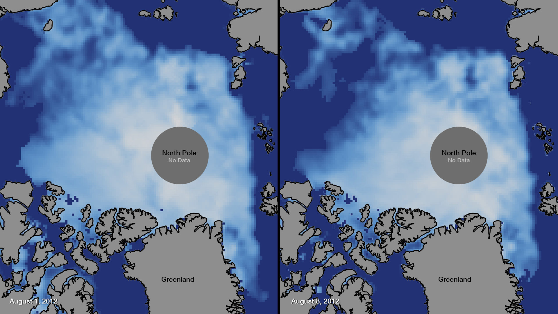
This image shows a before and after of the early August 2012 Arctic storm. In this image, the darkest blue colors indicate zero or very little ice concentrations. The brighter the colors, or whiter they become, the higher the ice concentrations become. After the storms pushed through the Arctic, ice concentrations were decreased. Image Credit: NOAA
This massive storm in the Arctic allowed a shift in Arctic sea ice concentrations across the region. Large reductions in the extent and concentration of sea ice can be seen in the left-hand side of each image above, where the Bering Sea empties into the Arctic Ocean. Strong polar lows in the Arctic can tear off large swaths of ice and push them to warmer locations. These storms can also mix up the ice and make it become slushy and upwell warmer waters to the surface. On average, Arctic cyclones last about 40 hours; as of August 9, 2012, this storm had lasted more than five days.
Arctic cyclones are more common during the summer than winter, and summer cyclones in the Arctic tend to be weaker than the storms that batter the region during the winter. According to Paul Newman, chief scientist for atmospheric sciences at NASA’s Goddard Space Flight Center, a storm this strong over the Arctic during the summer months is very unusual but not unheard-of. Newman stated that there have been about eight storms of similar strength during the month of August over the past 34 years of satellite records.

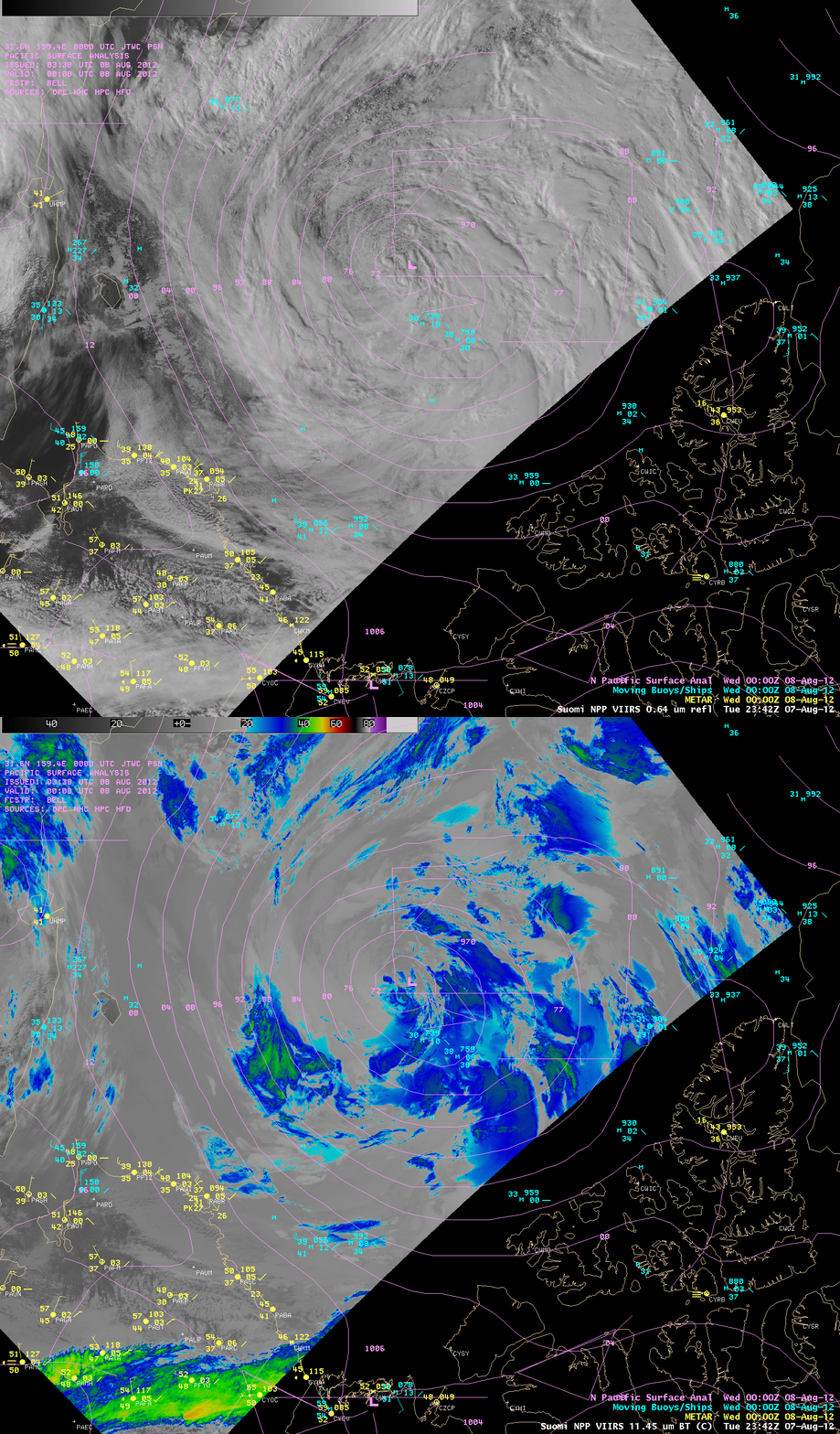
Suomi NPP VIIRS 0.64 µm visible channel + 11.45 µm IR channel images. Image Credit: CIMSS
The strong storm over the Arctic can have large implications for sea ice extent in the region. According to Claire Parkinson, a climate scientist at NASA Goddard:
This could lead to a more serious decay of the summertime ice cover than would have been the case otherwise, even perhaps leading to a new Arctic sea ice minimum. Decades ago, a storm of the same magnitude would have been less likely to have as large an impact on the sea ice because the ice cover was thicker and more expansive.

The year 2007 (dashed line) currently holds the record for minimum sea ice extent across the Arctic during September, the month that seasonal lows typically occur. This year, 2012, is on a path to beating 2007′s record low. Image Credit: National Snow and Ice Data Center
Sea ice minimum for the Arctic comes in September each year, before colder weather begins freezing the ice again. The year 2007 holds the record for the least Arctic sea ice observed in September, during the satellite era. Before the storm hit the Arctic in early August 2012, sea ice extent was already declining at record levels. According to the Arctic Sea Ice News and Analysis, the Arctic lost a total of 2.97 million square kilometers (1.15 million square miles) of ice this July. The low ice extent for the Arctic as a whole is primarily due to extensive open water on the Atlantic side of the Arctic located in the Kara, Laptev, Beaufort Sea and East Siberian seas. The largest July total loss, 3.53 million square kilometers (1.36 million square miles) occurred in the year 2007.
As melting increases each year, ice extent will slowly decrease as new ice that forms in the winter months has a better tendency of melting than older ice.

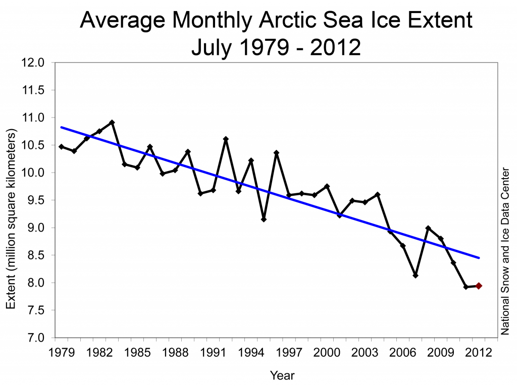
Monthly July ice extent for 1979 to 2012 shows a decline of 7.1% per decade. Image Credit: National Snow and Ice Data Center
Bottom line: A powerful polar low developed and pushed northward into the Arctic on August 5, 2012. The storm apparently helped break up Arctic sea ice, due to upwelling of warmer waters and the pushing of swaths of ice into warmer locations. Prio to the recent storm, sea ice extent in the Arctic had already been declining at record low levels across the region. We have another full month of melting before temperatures will slowly begin to drop again, as the winter months approach. Will 2012 beat out 2007 for record low sea ice extent since the satellite era? It is very possible, and there are no signs at the moment that the rapid melting of Arctic sea ice in 2012 is slowing down.


NASA finally admits it Arctic cyclone in August 'broke up' and 'wreaked havoc' on sea ice -- Reuters reports Arctic storm played 'key role' in ice reduction


http://www.climatedepot.com/a/17623/s.asp?tag=antarctica

In a September 18 video posted by NASA on its website, they admit that the Arctic cyclone, which began on August 5, “wreaked havoc on the Arctic sea ice cover" by "breaking up sea ice."
Global warming activists have been giddy in their hyping of the satellite era record low Arctic sea ice extent while ignoring the satellite era record sea ice expansion in the Antarctic.
Many climate activists have sought to downplay the significance that the Arctic cyclone played on this year's summer sea ice in the Arctic. But this new inconvenient video report from NASA now makes the warmists' attempt to deny the cyclones role in 2012's Arctic sea ice conditions -- impossible.
The September 18 NASA video notes: “A powerful storm wreaked havoc on the Arctic sea ice cover in August 2012. This visualization shows the strength and direction of the winds and their impact on the ice: the red vectors represent the fastest winds, while blue vectors stand for slower winds.”
Reuters news service filed a September 21 report based on NASA's video admission titled: “NASA says Arctic cyclone played 'key role' in record ice melt.” The news segment details how the Arctic sea ice was reduced due to “a powerful cyclone that scientists say 'wreaked havoc' on ice cover during the month of August.” (Reuters on “Arctic Cyclone” -- 0:47 second long segment -- Rob Muir reporting.)
Reuters - Sept. 21 – “NASA says a powerful cyclone formed off the coast of Alaska in early August and moved toward the center of the Arctic ocean, weakening the already thin sea ice as it went.
A large section North of the Chukchi Sea was cut off by the churning storm and pushed south to warmer waters where it melted.
The cyclone remained stalled over the arctic for several days...Scientists say a similar storm decades ago would have had much less impact on the sea ice because they say the ice was not as vulnerable then as it is now.”
#
#
Update: 'Uncommon event' -- NASA estimates there have only been about '8 storms of similar strength during August in the last 34 years.” NASA explains that the Arctic cyclone of August 5, had an “had an unusually low central pressure area.”
Excerpt: Paul A. Newman, chief scientist for Atmospheric Sciences at NASA's Goddard Space Flight Center in Greenbelt, Md., estimates that there have only been about eight storms of similar strength during the month of August in the last 34 years of satellite records. “It's an uncommon event, especially because it's occurring in the summer. Polar lows are more usual in the winter,” Newman said.
Arctic storms such as this one can have a large impact on the sea ice, causing it to melt rapidly through many mechanisms, such as tearing off large swaths of ice and pushing them to warmer sites, churning the ice and making it slushier, or lifting warmer waters from the depths of the Arctic Ocean.

“It seems that this storm has detached a large chunk of ice from the main sea ice pack. This could lead to a more serious decay of the summertime ice cover than would have been the case otherwise, even perhaps leading to a new Arctic sea ice minimum,” said Claire Parkinson, a climate scientist with NASA Goddard.
End NASA Excerpt
#
Update: 2012 Arctic ice loss was hyped: ' There's a terrible sense of deja vu about this story -- Winds 'wreaked havoc on the Arctic sea ice cover' -- 'This is exactly what happened in 2007' -- 2007 'when weeks of hype was followed by a quiet admission that the root cause of the loss of ice was winds and ocean currents. I had put the possibility that the 2012 ice loss was similarly down to factors other than global warming to Mark Brandon, a polar regions scientist. He agreed that this was very much a possibility and decried the poor coverage of the issue in the media'
Excerpt: Multiple peer-reviewed studies have shown that the 2007 low point in Arctic ice of the modern satellite era was due to high pressure days, unusual winds and ocean currents. In 2012, an analysis showed 'High Arctic Summers Have Been Colder Than Normal 12 Years In A Row' 'Every summer since the year 2000 has had below normal temperatures north of 80N'
In 2009, Arctic Ice Changes in past 3 years were blamed on 'shifting winds' - The Star Canada - July 28, 2009 - Excerpt: Oceanographer and Arctic researcher Jane Eert said "dramatic [Arctic ice] changes in the past three years are the result of shifting winds." "Enormous amounts of ice have 'been exported from the Arctic,' driven by winds that are shifting," according to Eert.
Here is a small sampling of studies on the causes of Arctic ice shifts:
A NASA study published in the peer-reviewed journal Geophysical Research Letters on October 4, 2007 found “unusual winds” in the Arctic blew "older thicker" ice to warmer southern waters. Despite the media's hyping of global warming, Ignatius Rigor, a co-author of the NASA study, explained, “While the total [Arctic] area of ice cover in recent winters has remained about the same, during the past two years an increased amount of older, thicker perennial sea ice was swept by winds out of the Arctic Ocean into the Greenland Sea. What grew in its place in the winters between 2005 and 2007 was a thin veneer of first-year sea ice, which simply has less mass to survive the summer melt.” [...] “Unusual atmospheric conditions set up wind patterns that compressed the sea ice, loaded it into the Transpolar Drift Stream and then sped its flow out of the Arctic,” said Son Nghiem of NASA's Jet Propulsion Laboratory and leader of the study. (LINK)
A November 2007 peer-reviewed study conducted by a team of NASA and university experts found cyclical changes in ocean currents impacting the Arctic. Excerpt: “Our study confirms many changes seen in upper Arctic Ocean circulation in the 1990s were mostly decadal in nature, rather than trends caused by global warming,”
NASA Study Blames Natural High Pressure Leading to More Sunny Days for Arctic Ice Reduction Excerpt: But experts say it was the peculiar weather Mother Nature offered up last summer - whatever caused it - that is largely to blame for the recent unusual events. There was a high-pressure system that sat over the Arctic for much of the summer. It shooed away clouds, leaving the sun alone to beat down.
A November 2007 peer-reviewed study in the journal Nature found natural cause for rapid Arctic warming. [The study] identifies a natural, cyclical flow of atmospheric energy around the Arctic Circle. A team of researchers, led by Rune Graversen of Stockholm University, conclude this energy flow may be responsible for the majority of recent Arctic warming. The study specifically rules out global warming or albedo changes from snow and ice loss as the cause, due to the “vertical structure” of the warming.

VIDEO: Passaggio a Nord Ovest - Best Explorer TG3 Lombardia 2/2/2013

Video link: http://youtu.be/z3cqj5h7FRQ


Saturday, February 2, 2013

New database on Arctic shipping and resources

The Centre for High North Logistics has launched ARCTIS, a dynamic searchable online database on shipping in Arctic waters, transportation infrastructure, mineral and energy resources, and innovative logistics solutions in the Arctic


Currently such information, data, and knowledge on the Arctic is scattered within a large number of organizations in several countries, Centre for High North Logistics (CHNL) writes in a press release. – Our goal is to collect all the most relevant information on above topics under one roof in ARCTIS.  No other database with such a focus exists today. 
CHNL strives to become the preferred gateway to information and knowledge for businesses, governments, and the research/educational community on shipping in Arctic waters and on Arctic marine transport infrastructure. 
The information in ARCTIS is arranged into eight main topics: Arctic Sea Ice & Climatology; Arctic Marine Transport & Logistics; Arctic Sea Routes; Arctic Maps & Charts; Arctic Energy & Mineral Resources; Arctic Policies & Governance;  People, Industries & Institutions; and a General topic.
ARCTIS will provide up-to-date and quality information on above topics managed by a group of more than 40 theme editors. 

Friday, February 1, 2013

Roger Swanson's Final Journey - CLOUD NINE


It may seem ironic that a mild-mannered Minnesotan would be considered one of the greatest ocean voyagers of our time, but Roger Swanson — who passed away late last month at the age of 81 — was precisely that. He logged nearly 220,000 sea miles during three decades of world exploration aboard his English-built Bowman 57, Cloud Nine, including three circumnavigations. After two previous tries, he became the first American skipper to transit the Northwest Passage in one season in 2007 (east to west). 


roger swanson
Roger Swanson didn't begin his globetrotting adventures until he turned 50. Since then, he logged enough sea miles to round the globe at the equator eight times. 
© 2013 David Thoreson

We had the pleasure of spending an afternoon with Roger and his wife Gaynelle (who began sailing with him in the mid-90s) when they passed through the Bay Area in 2001. Humble to a fault, and ever the gentleman, Roger charmed us with tales of adventures in all oceans and extreme latitudes. Born in 1931, he grew up in Minnesota, and it wasn’t until he “spent three years in Uncle Sam’s Yacht Club” at the end of the Korean War that he began developing a love of the sea. After the war, he went home and bought a pig farm despite his training as an engineer, but also started sailing scows as a hobby on Minnesota lakes.
A few years later, he and a Navy buddy did a sailing trip in the Bahamas in a rented boat, which he says "started it all." In the ‘70s, when the bareboating industry was just taking shape in the Caribbean, Swanson bought a CSY 44 and kept it in that pioneering company’s fleet. For a decade he made frequent forays to the islands to placate his sailing urges, but on his 50th birthday in 1981, he had a revelation. “At the dinner table my daughter suddenly said, ‘So Dad, when are you going to sail around the world?’ I wasn’t feeling too good about turning 50,” he recalls, “and I decided that if I was ever going to do anything like that, I’d better get started.” Within a matter of months he'd rearranged his priorities, sold the charter boat and purchased Cloud Nine. The next year he, his two sons and two friends took off from Miami on a westward circumnavigation (through both canals), with a side trip to Japan.
Unlike many world cruisers, though, Swanson didn’t ‘sell the farm’ to make the trip. On the contrary, he arranged for employees to keep that business going, as well as several other businesses he owned, while he traveled. That strategy supported his adventures to the end.
Swanson's exploits earned him the Cruising Club of America’s Blue Water Medal, the Royal Cruising Club’s Tilman Medal, and he was inducted into Cruising World’s Hall of Fame. He will surely be missed by those whose lives he touched.
- latitude / andy

http://www.latitude38.com/lectronic/lectronicday.lasso?date=2013-01-23#Story4


Saturday, January 12, 2013

Nicolas Peissel of BELZEBUB2 will talk about 2012 Northwest Passage - QUESTIONS & ANSWERS ???

http://www.thespec.com/news/local/article/868549--signpost-northwest-passage-voyage


Nicolas Peissel will talk about his summer 2012 voyage through the Northwest Passage in a small sailboat at a free public talk Jan 12, 2013
The lecture and photo recollection will be held at 8 p.m. in room 1A1 in the Ewart Angus Centre at the McMaster hospital building. For more information, visit haalsa.org
Questions that the crew on BELZEBUB2 should answer:
1. Did you have a GPS aboard BELZEBUB2?
2. Did you download the GPS tracklines to your computer?
3. When you video recorded your voyage, why did you not show the GPS positions displayed by the GPS unit?
4. Did you observe at any time the POLAR BOUND commanded by David Scott Cowper?
5. Did you attempt to contact POLAR BOUND by VHF radio during your voyage?
6. What evidence do you have of the actual route you claim to have navigated? 
7. Did your webmaster handcraft your website voyage route graphic? Who is your webmaster?
8. Why do you claim to have navigated the McClure Strait route without so much as a Spot GPS tracker for proof?
9. Does any of your pictures or videos show headlands or prominent landmarks? Please provide captions to said graphics on your website,
10. What are your future voyaging plans?

Journey's end for Arctic heroes

LOCAL HEROES who risked their lives in the Arctic Convoys of the Second World War 70 years ago will be rewarded with a medal from the British Government.


The announcement by Prime Minister David Cameron was welcomed this week by Eccleshall Arctic Convoy veteran Donald Gray, Stone MP Bill Cash and Joyce Farnham, president of Stone’s Royal British Legion women’s branch.

Councillor Farnham’s campaign to honour the Arctic Convoy veterans was featured in the Newsletter last year.

She said: “It’s excellent news and everybody is so delighted about it. I think there are only about 200 veterans left but it is better late than never.”

Mr Cash paid tribute to Councillor Farnham’s efforts and John Caudwell’s financial support for a memorial for Bomber Command, unveiled in London last year.

He said: “I am delighted that both the Arctic Convoy veterans and Bomber Command are at last being honoured.”

Mr Gray, 89, embarked on six perilous Arctic Convoy missions between 1944 and 1945. He endured freezing conditions to escort vital supply ships through Arctic waters to Russia.

He was awarded the Russian Medal by the Russian Government in 1988 but it took 62 years for the British Government to issue an Arctic Badge, let alone a medal.

Wartime Prime Minister Winston Churchill described the convoy route as “the worst journey in the world”.

Mr Gray said: “I was pleased to hear they are going to issue a medal – we have waited for 70 years.”

http://www.staffordshirenewsletter.co.uk/News/Journeys-end-for-Arctic-heroes-10012013.htm


Friday, January 11, 2013

S/V BEST EXPLORER (ITA) - 2012 NWP Video Recap

Video Link: http://www.youtube.com/watch?feature=player_detailpage&v=rfKJ4M7zCQk

Website: http://www.nordovestitalia.org/


Students on Ice expedition provides unique learning experience for youth


Fisheries and Aquaculture Minister Derrick Dalley.


The provincial government is providing $12,000 in financial support to allow a student from Newfoundland and Labrador to participate in the 2013 Students on Ice Expedition later this year.

The Students on Ice program is an educational expedition that takes place in the Arctic region. It focuses on learning about the environment and exploring the unique landscape of the northernmost area of the globe.

“The Students on Ice program offers a valuable opportunity for young students to experience first-hand Canada’s unique Arctic ecosystem,” said Fisheries and Aquaculture Minister Derrick Dalley. “Our government is very supportive of such initiatives, which encourage youth to become involved in activities that promote science and education, and provide a greater understanding of our marine environment and conservation issues.”

The program provides for in-depth learning about the Arctic environment and northern Indigenous cultures, while participants explore solutions to pressing global challenges. Participants are also inspired to make a difference in their own communities.

The 2013 excursion will explore the eastern Canadian Arctic and western Greenland between July 14 and 28. It will involve 70 international high school students, 14 to 18 years old, a team of 35 scientists, historians, artists, explorers, educators, innovators and polar experts, and 30 public and private sector leaders.

“Participants on Students on Ice expeditions become exceptional polar ambassadors who work to raise awareness in their home communities about the importance of many polar and global issues,” said Geoff Green, founder and executive director of Students on Ice. “We are delighted that once again this year, thanks to the Government of Newfoundland and Labrador, a student from Newfoundland and Labrador will get the opportunity to visit the Canadian Arctic, one of the world’s most unique places, and then bring back the knowledge they have gained to their friends, family, schools and communities. On behalf of Students on Ice and our many partners, I sincerely thank the Government of Newfoundland and Labrador for contributing to the Students on Ice Arctic expedition and providing young people with a meaningful, positive and profound experience in their lives.”

While on the expedition, students participate in lectures, workshops, hands-on activities and small group seminars. They also have extraordinary wildlife encounters, educational day excursions, visits to remote Arctic communities and archeological sites, and opportunities to acquire first-hand knowledge and insight into the dynamics of climate change. This year marks the sixth Newfoundland and Labrador student sponsored to participate in the Students on Ice Arctic Expedition under the department's Coastal and Oceans Strategy program. About $59,800 in funding has been provided since 2010.

More information on the Students on Ice program can be found by visiting www.studentsonice.com


Thursday, January 10, 2013

Canadian Arctic Expedition Proof Silver Dollar


FROZEN IN TIME IN PHOTOS AND FILM, THE 100 YEAR-OLD CANADIAN ARCTIC EXPEDITION IS NOW CAPTURED ON THE ROYAL CANADIAN MINT’S 2013 PROOF SILVER DOLLAR
Passionate about making people discover Canada through its coins, the Royal Canadian Mint is today pleased to commemorate the watershed discoveries of the 1913 Canadian Arctic Expedition on its 2013 Proof Silver Dollar. This flagship of the Mint’s collector coin program celebrates another milestone of Canadian history by reviving the fascinating story of intrepid explorers, mapping Canada’s Far North and studying its people, wildlife and resources to gain knowledge and understanding of previously unseen and unvisited parts of our planet. The legacy of this historic undertaking is now preserved in 99.99% pure silver on the 2013 Proof Silver Dollar and several other 2013 Mint collector products.
camint arctic exped silver proof dollar lg Canadian Arctic Expedition Proof Silver Dollar
“The Royal Canadian Mint is proud to issue a great variety of collector coins which bring events of our past back to life and spark interest in learning more about Canada’s fascinating history,” saidIan E. Bennett, President and CEO of the Royal Canadian Mint. “The Canadian Arctic Expedition was one of our greatest adventures of the early 20th century and we are delighted to bring back the spirit of exploration and discovery by devoting our 2013 Proof Silver Dollar to its 100th anniversary”.
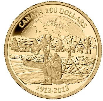
camint gold arctic Canadian Arctic Expedition Proof Silver DollarIn addition to the 2013 Proof Silver Dollar, the 100th anniversary of the Canadian Arctic Expedition is commemorated on: the 2013 Brilliant Silver Dollar; the 2013 Fine Silver Proof Set; the 2013 $100 Gold Coin; and a duo of 99.99% pure gold and silver kilo coins. All these products can be ordered by directly contacting the Royal Canadian Mint at 1-800-267-1871 in Canada, 1-800-268-6468 in the US, or on the Internet at www.mint.ca. These coins will also be sold at the Mint’s boutiques in Ottawa, Winnipeg and Vancouver as well as through the Mint’s global network of dealers and distributors, including participating Canada Post outlets. Please see attached backgrounder for further product information.
About the Royal Canadian Mint

The Royal Canadian Mint is the Crown Corporation responsible for the minting and distribution of Canada’s circulation coins. An ISO 9001-2008 certified company, the Mint is recognized as one of the largest and most versatile mints in the world, offering a wide range of specialized, high quality coinage products and related services on an international scale. For more information on the Mint, its products and services, visit. www.mint.ca
http://www.coinweek.com/world-mints/world-mint-news/canadian-arctic-expedition-proof-silver-dollar/

Arctic Oscillation switches to negative phase - colder winters means later ice openings?

http://nsidc.org/arcticseaicenews/2013/01/arctic-oscillation-switches-to-negative-phase/

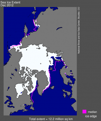
Arctic sea ice extent for December 2012 remained far below average, driven by anomalously low ice conditions in the Kara, Barents, and Labrador seas. Thus far, the winter has been dominated by the negative phase of the Arctic Oscillation, bringing colder than average conditions to Scandinavia, Siberia, Alaska, and Canada.


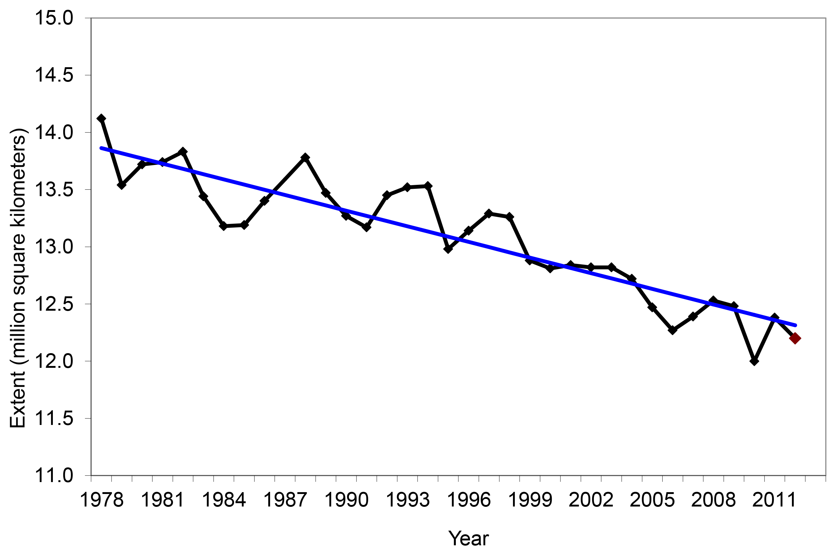
The average sea ice extent for December 2012 was 12.20 million square kilometers (4.71 million square miles). This is 1.16 million square kilometers (448,000 square miles) below the 1979 to 2000 average for the month, and is the second-lowest December extent in the satellite record.
At the end of December, ice extent in the Atlantic sector remained far below normal, as parts of the Kara and Barents seas remained ice-free. Ice has also been slow to form in the Labrador Sea, while Hudson Bay is now completely iced over. On the Pacific side, ice extent is slightly above normal, with the ice edge in the Bering Sea extending further to the south than usual. The Bering Sea has seen above-average winter ice extent in recent years and is the only region of the Arctic that has exhibited a slightly positive trend in ice extent during the winter months.
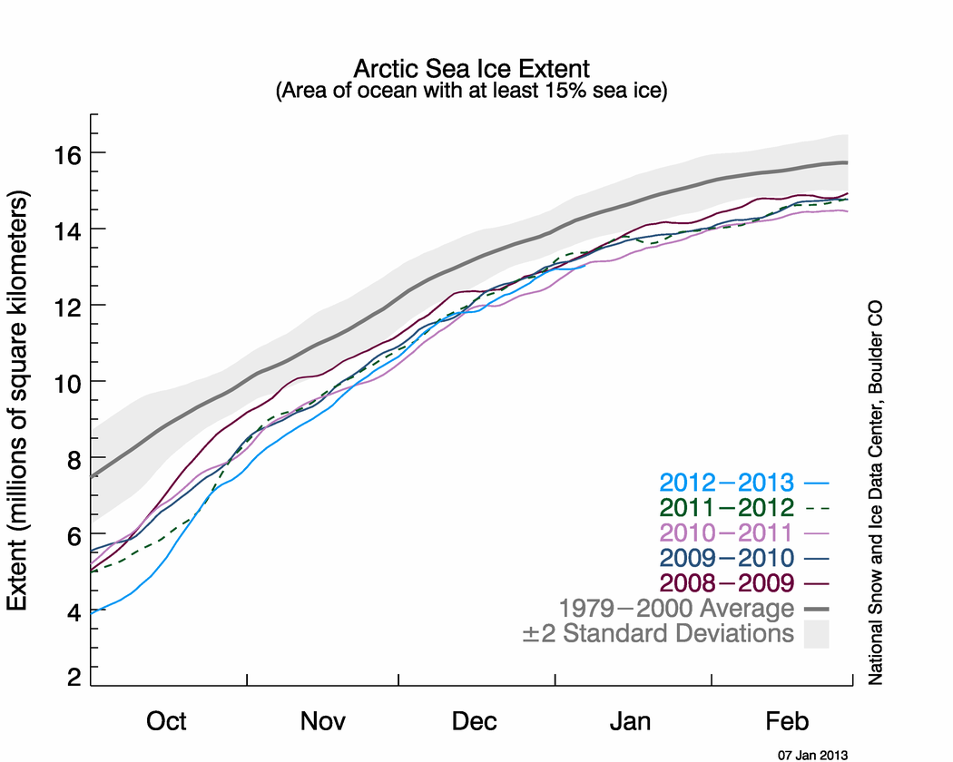
Figure 2. The graph above shows Arctic sea ice extent as of January 7, 2013, along with daily ice extent data for the previous five years. 2012 to 2013 is shown in blue, 2011 to 2012 in green, 2010 to 2011 in pink, 2009 to 2010 in navy, and 2008 to 2009 in purple. The 1979 to 2000 average is in dark gray. The gray area around this average line shows the two standard deviation range of the data. Sea Ice Index data.

Although the Arctic gained 2.33 million square kilometers of ice (900,000 square miles) through the month, ice extent in the region remained far below average. Ice growth remained slow in the Kara and Barents seas where air temperatures were 3 to 5 degrees Celsius (5 to 9 degrees Fahrenheit) higher than normal. Air temperatures over Greenland and the Canadian Archipelago were also slightly above average, while temperatures over Alaska were 2 to 7 degrees Celsius (4 to 13 degrees Fahrenheit) lower than average.
Winter sea ice variability is largely confined to the peripheral seas surrounding the Arctic Ocean. In the past, the dominant pattern of winter sea ice variability showed a distinct out-of-phase relationship between the Labrador and Greenland-Barents seas, with a less prominent seesaw pattern in the Pacific sector, between the Bering Sea and the Sea of Okhotsk. In recent winters however, this out-of-phase relationship no longer appears to hold in the Atlantic sector. Ice extent has remained below average in both the Labrador and the Barents seas.
Successive winters with anomalously low sea ice in the North Atlantic have led to higher mortality rates for seals in the region. The United States government recently added the bearded and ringed seals to the list of creatures threatened under the Endangered Species Act.
Figure 3. Monthly December ice extent for 1979 to 2012 shows a decline of -3.5 percent per decade. 

Average Arctic sea ice extent for December 2012 was the second lowest for the month in the satellite record. Through 2012, the linear rate of decline for December ice extent is -3.5 percent per decade relative to the 1979 to 2000 average. While the winter ice extent for the Arctic as a whole shows only modest declines, large negative trends are now found in nearly all of the peripheral seas, with the exception of the Bering Sea.
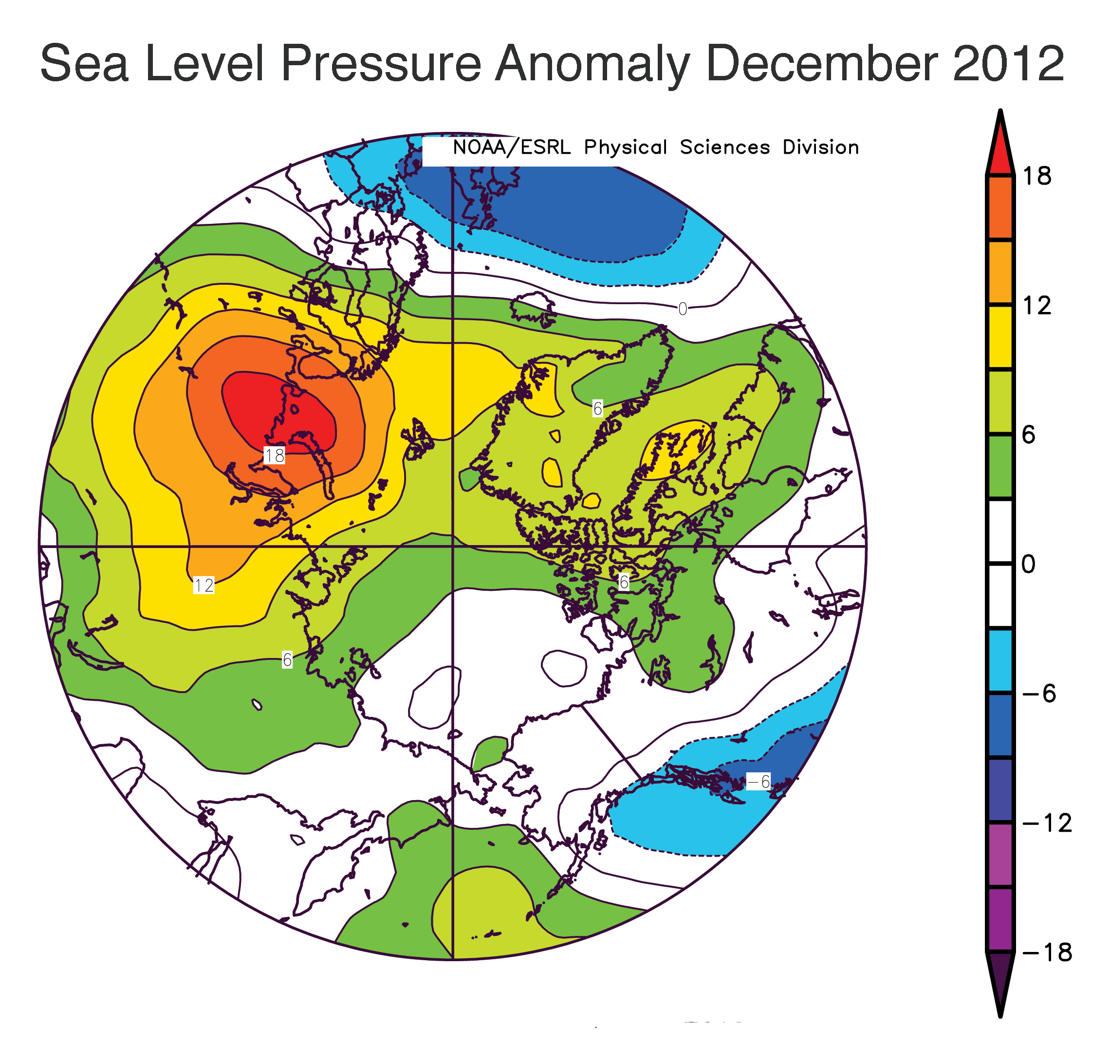
Figure 4. This image shows sea level pressure anomalies averaged for December 2012, compared to averages over the period 1981 to 2010. Sea level pressure was above average over Eurasia, extending into the Kara and Barents seas, and across Greenland and the Canadian Archipelago.

The most important mode of variation in the Arctic’s winter atmospheric circulation is the Arctic Oscillation. When the Arctic Oscillation is in a negative mode or phase, sea level pressure is higher than normal over the central Arctic and lower than normal over middle latitudes. This pattern tends to keep the high Arctic relatively warm. It brings colder weather to Europe and North America because air masses can cross into and out of the high Arctic more easily. This pattern tends to favor the retention of thick ice in the Arctic basin by reducing the outflow of ice through the Fram Strait and strengthening the Beaufort Gyre, a clockwise circular pattern of ice drift in the central Arctic. The opposite conditions generally hold for a positive Arctic Oscillation pattern.
The specific influence of this winter’s negative Arctic Oscillation will depend not only on the strength of the sea level pressure anomaly, but also on the location of the sea level pressure center of action. While a negative Arctic Oscillation pattern tends to favor more ice in summer, this was not the case during the extreme negative Arctic Oscillation winter of 2009 to 2010.
The overall effect on the ice cover remains to be seen. Recent studies have argued that that strong warming of the atmosphere in autumn from summer sea ice loss favor the negative Arctic Oscillation phase.
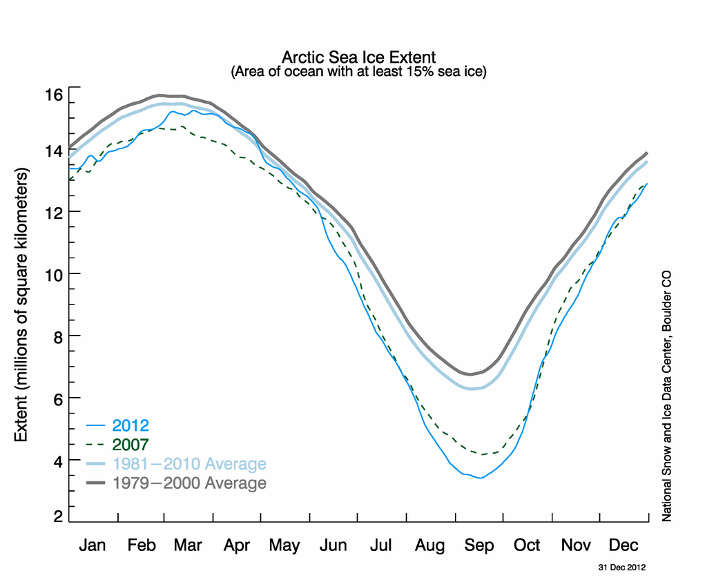
Figure 5. The graph above shows January to December Arctic sea ice extent for the two lowest extent years in the satellite record. Year 2012 is shown in blue and 2007 is shown in green. The 1981 to 2010 average is shown in light blue while the 1979 to 2000 average is in dark gray. Sea Ice Index data. About the data 

While the year began with lower than average extent for the Arctic as a whole, extent in the Bering Sea was at record high levels for much of the winter. The seasonal decline of ice extent began slowly, such that in mid-April, extent for the Arctic as a whole was briefly near average levels.
Extent began dropping rapidly beginning in May, and by the end of the melt season on September 16, extent was at the lowest level recorded in the satellite record of 3.41 million square kilometers (1.32 million square miles). While summer weather conditions were not as favorable for ice loss as during 2007, the year of the previous record low, an unusually strong cyclone in August helped to quickly break up the already thin and fragmented ice cover in the Chukchi Sea. This cyclone—remarkable in its intensity and its duration—lasted for thirteen days, of which ten days were spent in the Arctic basin.
While it appears that a record low extent would have been reached even without the cyclone, thinning over the last several decades has made the ice more vulnerable to such storms, compared to earlier decades when the Arctic Ocean was dominated by thick, multiyear ice.
The annual average extent is now declining at a rate of -4.5 percent per decade relative to the 1979 to 2000 average and -4.6 percent per decade relative to the 1981 to 2010 average. The 1981 to 2010 period is the 30-year climatology used by the National Oceanic and Atmospheric Administration (NOAA) for their climate normals. Thirty years is a commonly-used period to define average or normal climate conditions. It is long enough to capture much climate variability, such as the different modes of the Arctic Oscillation, and short enough to be relevant for human timescales, such as agricultural cycles. NOAA updates its climate normals every ten years. For Arctic sea ice, use of the 1981 to 2010 period results in a lower extent than the 1979 to 2000 period, as seen in Figure 5, because the low extents of the last decade are included.
Record low ice extent was not the only remarkable event in the north. In June, Northern Hemisphere land snow cover set a new record for the least amount of snow cover in the 45-year record. A month later, the Greenland ice sheet experienced melt over more than 90 percent of its surface area, the largest melt extent recorded during the satellite data record.

Further reading

Simmonds, I. and I. Rudeva.  2012. The great Arctic cyclone of August 2012. Geophysical Research Letters39, L23709, doi:10.1029/2012GL054259.
Jaiser, R., K. Dethloff, D. Handorf, A. Rinke, and J. Cohen. 2011. Impact of sea ice cover changes on the Northern Hemisphere atmospheric winter circulation. Tellus A, 64, 11595, doi:10.3402/tellusa.v64i0.11595.
Stroeve, J. C., J. Maslanik, M. C. Serreze, I. Rigor, W. Meier, and C. Fowler. 2011. Sea ice response to an extreme negative phase of the Arctic Oscillation during winter 2009/2010, Geophysical Research Letters 38, L02502, doi:10.1029/2010GL045662.