Since the storm, which was equal in strength to a hurricane, tore across the Arctic, scientists have wondered whether its winds and waves were a guilty party in the disappearing Arctic sea ice.
Guilty or not guilty?
To solve the mystery, climate scientists from the University of Washington performed the equivalent of a forensic exam: They ran a computer simulation of last summer's weather and compared it against a second scenario that was identical, except that there was no cyclone.
"The storm was enormous," study co-author Axel Schweiger, a polar scientist in the university'sApplied Physics Laboratory, said in a statement. "The impact on the ice was immediately obvious, but the question was whether the ice that went away during the storm would have melted anyway because it was thin to begin with."
Though the storm had a huge impact on sea ice while it passed, within two weeks, the effect diminished, lead author Jinlun Zhang, also a scientist in the university's Applied Physics Laboratory, said in the statement.
The final verdict? Not guilty
The scientists conclude the cyclone reduced the final September ice extent by almost 60,000 square miles (150,000 square kilometers), an additional 5 percent. However, they point out that 2012's record loss was 18 percent greater than the previous low, set in 2007. [Video: Powerful Arctic Cyclone Wreaks Havoc on Sea Ice]
"Thus without the storm, 2012 would still have produced a record minimum," the authors report in their study, which appears online this week in the journal Geophysical Research Letters.
Warmed from below
The research also revealed an unusual mechanism for the cyclone-related melting. A study published Dec. 15, 2012, in the same journal focused on winds breaking up the ice or driving ice floes into areas of warmer water.
But the University of Washington team found that during the storm, the ice melted largely from warm ocean water churned up by the passing storm. Melting quadrupled during the storm, and the rate of ice loss doubled, the study found.
In the Arctic summer, ocean water becomes stratified from melting ice, according to a statement from the university. A layer of ice-cold fresh watersits just beneath the sea ice. But about 65 feet (20 meters) below the surface, there is a layer of denser, saltier water that has been gradually warmed by the sun's rays.
When the cyclone swept over the drifting ice floes, underside ridges churned up the water, bringing sun-warmed seawater to the ice's bottom edge and causing it to melt, the study suggests.
http://news.yahoo.com/arctic-csi-cyclone-absolved-record-sea-ice-melt-183425183.html
10 Things You Need to Know about Arctic Sea Ice
Powerful summer storm in Arctic reduces sea ice
http://earthsky.org/earth/powerful-summer-storm-in-arctic-reduces-sea-ice-even-more
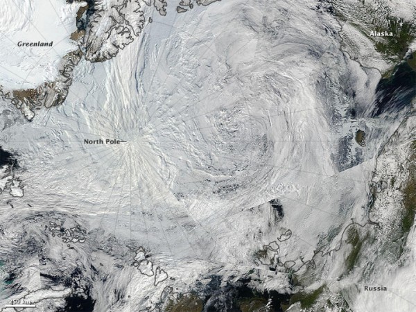
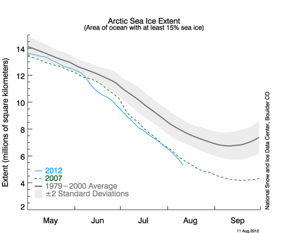
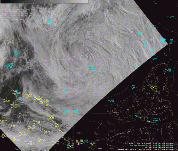
As reported earlier via EarthSky, the extent of Arctic sea ice in 2012 appears to be heading toward a new record low. On August 1, ice extent was already below levels recorded for the same date in 2007, the year that currently holds the record for minimum ice extent in September, according to the National Snow and Ice Data Center. Adding to the already diminished ice extent across the Arctic was an unusually large, long-lasting, and powerful storm that pushed through the region around August 5 through August 8, 2012. A very strong area of low pressure pushed northward into the Arctic and intensified through that time period. The storm dropped to 965 hPa central pressure, which is extremely low and highly unusual for the Arctic at this time of the year. The storm apparently contributed to some of the melting that was already occurring in the Arctic. When the melting phase ends by the middle of September, 2012 might break 2007′s record low for Arctic sea ice.

NASA’s Aqua satellite captured this natural-color image of the storm in the Arctic on August 7, 2012. The storm – which appears as a swirl – is directly over the Arctic in this image. NASA image by Jeff Schmaltz, LANCE/EOSDIS Rapid Response.

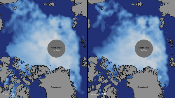
This image shows a before and after of the early August 2012 Arctic storm. In this image, the darkest blue colors indicate zero or very little ice concentrations. The brighter the colors, or whiter they become, the higher the ice concentrations become. After the storms pushed through the Arctic, ice concentrations were decreased. Image Credit: NOAA
This massive storm in the Arctic allowed a shift in Arctic sea ice concentrations across the region. Large reductions in the extent and concentration of sea ice can be seen in the left-hand side of each image above, where the Bering Sea empties into the Arctic Ocean. Strong polar lows in the Arctic can tear off large swaths of ice and push them to warmer locations. These storms can also mix up the ice and make it become slushy and upwell warmer waters to the surface. On average, Arctic cyclones last about 40 hours; as of August 9, 2012, this storm had lasted more than five days.
Arctic cyclones are more common during the summer than winter, and summer cyclones in the Arctic tend to be weaker than the storms that batter the region during the winter. According to Paul Newman, chief scientist for atmospheric sciences at NASA’s Goddard Space Flight Center, a storm this strong over the Arctic during the summer months is very unusual but not unheard-of. Newman stated that there have been about eight storms of similar strength during the month of August over the past 34 years of satellite records.
The strong storm over the Arctic can have large implications for sea ice extent in the region. According to Claire Parkinson, a climate scientist at NASA Goddard:
This could lead to a more serious decay of the summertime ice cover than would have been the case otherwise, even perhaps leading to a new Arctic sea ice minimum. Decades ago, a storm of the same magnitude would have been less likely to have as large an impact on the sea ice because the ice cover was thicker and more expansive.

The year 2007 (dashed line) currently holds the record for minimum sea ice extent across the Arctic during September, the month that seasonal lows typically occur. This year, 2012, is on a path to beating 2007′s record low. Image Credit: National Snow and Ice Data Center
Sea ice minimum for the Arctic comes in September each year, before colder weather begins freezing the ice again. The year 2007 holds the record for the least Arctic sea ice observed in September, during the satellite era. Before the storm hit the Arctic in early August 2012, sea ice extent was already declining at record levels. According to the Arctic Sea Ice News and Analysis, the Arctic lost a total of 2.97 million square kilometers (1.15 million square miles) of ice this July. The low ice extent for the Arctic as a whole is primarily due to extensive open water on the Atlantic side of the Arctic located in the Kara, Laptev, Beaufort Sea and East Siberian seas. The largest July total loss, 3.53 million square kilometers (1.36 million square miles) occurred in the year 2007.
As melting increases each year, ice extent will slowly decrease as new ice that forms in the winter months has a better tendency of melting than older ice.

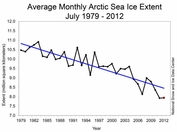
Monthly July ice extent for 1979 to 2012 shows a decline of 7.1% per decade. Image Credit: National Snow and Ice Data Center
Bottom line: A powerful polar low developed and pushed northward into the Arctic on August 5, 2012. The storm apparently helped break up Arctic sea ice, due to upwelling of warmer waters and the pushing of swaths of ice into warmer locations. Prio to the recent storm, sea ice extent in the Arctic had already been declining at record low levels across the region. We have another full month of melting before temperatures will slowly begin to drop again, as the winter months approach. Will 2012 beat out 2007 for record low sea ice extent since the satellite era? It is very possible, and there are no signs at the moment that the rapid melting of Arctic sea ice in 2012 is slowing down.
NASA finally admits it Arctic cyclone in August 'broke up' and 'wreaked havoc' on sea ice -- Reuters reports Arctic storm played 'key role' in ice reduction
http://www.climatedepot.com/a/17623/s.asp?tag=antarctica
In a September 18 video posted by NASA on its website, they admit that the Arctic cyclone, which began on August 5, “wreaked havoc on the Arctic sea ice cover" by "breaking up sea ice."
Global warming activists have been giddy in their hyping of the satellite era record low Arctic sea ice extent while ignoring the satellite era record sea ice expansion in the Antarctic.
Many climate activists have sought to downplay the significance that the Arctic cyclone played on this year's summer sea ice in the Arctic. But this new inconvenient video report from NASA now makes the warmists' attempt to deny the cyclones role in 2012's Arctic sea ice conditions -- impossible.
The September 18 NASA video notes: “A powerful storm wreaked havoc on the Arctic sea ice cover in August 2012. This visualization shows the strength and direction of the winds and their impact on the ice: the red vectors represent the fastest winds, while blue vectors stand for slower winds.”
Reuters news service filed a September 21 report based on NASA's video admission titled: “NASA says Arctic cyclone played 'key role' in record ice melt.” The news segment details how the Arctic sea ice was reduced due to “a powerful cyclone that scientists say 'wreaked havoc' on ice cover during the month of August.” (Reuters on “Arctic Cyclone” -- 0:47 second long segment -- Rob Muir reporting.)
Reuters - Sept. 21 – “NASA says a powerful cyclone formed off the coast of Alaska in early August and moved toward the center of the Arctic ocean, weakening the already thin sea ice as it went.
A large section North of the Chukchi Sea was cut off by the churning storm and pushed south to warmer waters where it melted.
The cyclone remained stalled over the arctic for several days...Scientists say a similar storm decades ago would have had much less impact on the sea ice because they say the ice was not as vulnerable then as it is now.”
#
End Reuters news segment.
#
Update: 'Uncommon event' -- NASA estimates there have only been about '8 storms of similar strength during August in the last 34 years.” NASA explains that the Arctic cyclone of August 5, had an “had an unusually low central pressure area.”
Excerpt: Paul A. Newman, chief scientist for Atmospheric Sciences at NASA's Goddard Space Flight Center in Greenbelt, Md., estimates that there have only been about eight storms of similar strength during the month of August in the last 34 years of satellite records. “It's an uncommon event, especially because it's occurring in the summer. Polar lows are more usual in the winter,” Newman said.
Arctic storms such as this one can have a large impact on the sea ice, causing it to melt rapidly through many mechanisms, such as tearing off large swaths of ice and pushing them to warmer sites, churning the ice and making it slushier, or lifting warmer waters from the depths of the Arctic Ocean.
“It seems that this storm has detached a large chunk of ice from the main sea ice pack. This could lead to a more serious decay of the summertime ice cover than would have been the case otherwise, even perhaps leading to a new Arctic sea ice minimum,” said Claire Parkinson, a climate scientist with NASA Goddard.
“It seems that this storm has detached a large chunk of ice from the main sea ice pack. This could lead to a more serious decay of the summertime ice cover than would have been the case otherwise, even perhaps leading to a new Arctic sea ice minimum,” said Claire Parkinson, a climate scientist with NASA Goddard.
End NASA Excerpt
#
Update: 2012 Arctic ice loss was hyped: ' There's a terrible sense of deja vu about this story -- Winds 'wreaked havoc on the Arctic sea ice cover' -- 'This is exactly what happened in 2007' -- 2007 'when weeks of hype was followed by a quiet admission that the root cause of the loss of ice was winds and ocean currents. I had put the possibility that the 2012 ice loss was similarly down to factors other than global warming to Mark Brandon, a polar regions scientist. He agreed that this was very much a possibility and decried the poor coverage of the issue in the media'
Climate Depot concurs with the above analysis. See: Don't Panic! Arctic Ice Hits 'Record' Low!? Climate Depot Explains Arctic melting hype
Excerpt: Multiple peer-reviewed studies have shown that the 2007 low point in Arctic ice of the modern satellite era was due to high pressure days, unusual winds and ocean currents. In 2012, an analysis showed 'High Arctic Summers Have Been Colder Than Normal 12 Years In A Row' 'Every summer since the year 2000 has had below normal temperatures north of 80N'
In 2009, Arctic Ice Changes in past 3 years were blamed on 'shifting winds' - The Star Canada - July 28, 2009 - Excerpt: Oceanographer and Arctic researcher Jane Eert said "dramatic [Arctic ice] changes in the past three years are the result of shifting winds." "Enormous amounts of ice have 'been exported from the Arctic,' driven by winds that are shifting," according to Eert.
Here is a small sampling of studies on the causes of Arctic ice shifts:
A NASA study published in the peer-reviewed journal Geophysical Research Letters on October 4, 2007 found “unusual winds” in the Arctic blew "older thicker" ice to warmer southern waters. Despite the media's hyping of global warming, Ignatius Rigor, a co-author of the NASA study, explained, “While the total [Arctic] area of ice cover in recent winters has remained about the same, during the past two years an increased amount of older, thicker perennial sea ice was swept by winds out of the Arctic Ocean into the Greenland Sea. What grew in its place in the winters between 2005 and 2007 was a thin veneer of first-year sea ice, which simply has less mass to survive the summer melt.” [...] “Unusual atmospheric conditions set up wind patterns that compressed the sea ice, loaded it into the Transpolar Drift Stream and then sped its flow out of the Arctic,” said Son Nghiem of NASA's Jet Propulsion Laboratory and leader of the study. (LINK)
A November 2007 peer-reviewed study conducted by a team of NASA and university experts found cyclical changes in ocean currents impacting the Arctic. Excerpt: “Our study confirms many changes seen in upper Arctic Ocean circulation in the 1990s were mostly decadal in nature, rather than trends caused by global warming,”
NASA Study Blames Natural High Pressure Leading to More Sunny Days for Arctic Ice Reduction Excerpt: But experts say it was the peculiar weather Mother Nature offered up last summer - whatever caused it - that is largely to blame for the recent unusual events. There was a high-pressure system that sat over the Arctic for much of the summer. It shooed away clouds, leaving the sun alone to beat down.
A November 2007 peer-reviewed study in the journal Nature found natural cause for rapid Arctic warming. [The study] identifies a natural, cyclical flow of atmospheric energy around the Arctic Circle. A team of researchers, led by Rune Graversen of Stockholm University, conclude this energy flow may be responsible for the majority of recent Arctic warming. The study specifically rules out global warming or albedo changes from snow and ice loss as the cause, due to the “vertical structure” of the warming.
No comments:
Post a Comment
Enter your comment(s) here...