(FAIRUSE NOTICE: This blog site may contain copyrighted material. Such material is made available for educational purposes only. This constitutes a 'Fair Use' of any such copyrighted material as provided for in Title 17 USC Section 107 of the US Copyright Law.)
FYI - TREKKING IN THE ARCTIC IS ONE THING... BUT TO SAY CROSSING THE "NORTHWEST PASSAGE" REQUIRES A SEA ROUTE NAVIGATION BETWEEN THE BERING SEA ARCTIC CIRCLE THROUGH THE ARCTIC ON YOUR OWN VESSEL'S BOTTOM TO THE OPPOSITE ARCTIC CIRCLE IN THE ATLANTIC'S DAVIS STRAIT. ANYTHING LESS IS A POINT-TO-POINT VOYAGE, SUCH AS BETWEEN HAMLETS TUKTOYAKTUK AND POND INLET.
YOU HAVE NOT CLIMBED MOUNT EVEREST BY REACHING BASE CAMP - WITHOUT SUMMITING YOU HAVE NOT CLIMBED MOUNT EVEREST. LIKEWISE, A NORTHWEST PASSAGE MEANS NAVIGATING A SEA ROUTE BETWEEN ATLANTIC AND PACIFIC ARCTIC CIRCLES. A DEFINED STARTING POINT TO THE DEFINED FINISH LINE BE IT EAST TO WEST OR WEST TO EAST.
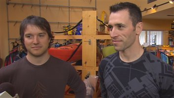
Olivier Giasson and Sebastien Lapierre attempt to cross at once the passage of Northwest sea kayak, a first.
Two firefighters from Quebec will try to cross the Northwest Passage in the Arctic sea kayaking in a single season.An expedition ever undertaken to date.
The expedition " Ice Dream 2013 "is to achieve a world first in the field of sports expeditions and sea kayaking in fact we try to make the first crossing of the Northwest Passage in a single season by sea kayak . Several years ago, the melting of Arctic sea ice releases the Northwest Passage for a period allowing us to paddle the distance in a single season.
Because of global warming, Sebastien Lapierre and Olivier Giasson believe they can cross this year 4500 km of icebound several months a year pass. They will leave on July 15 and plan to get there in three months. "It is a matter of timing . We must follow the thaw ice. Then we'll see if our estimate is good, "said Sebastien Lapierre.
The Northwest Passage is a coveted passage could be fréquentable by ships in the next few years because of global warming. Kayakers have already crossed several seasons, stopping the return of ice and returning the following year. Continuously, so it would be a first.
The two men are organizing this challenge requires great preparation for two years. "We can not rely on what others have done before. It is a little precursor there. To look for, you must be sure to think of everything. And it takes us contacts there, "says Sebastien Lapierre.
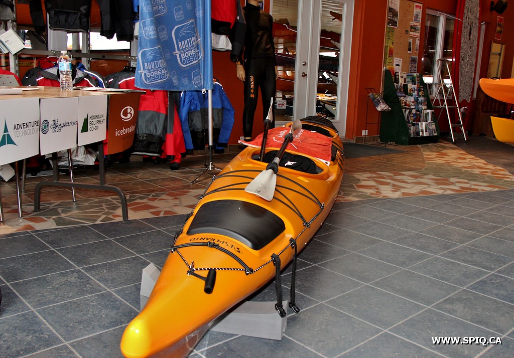
The two adventurers set five stops to refuel. The expedition will take place in tandem kayak.
The two kayakers train mainly in the river, opposite Quebec. In early spring and late fall, we find similar conditions that they encounter in the Arctic. "The tides, cold water conditions, the outdoor temperature is very similar. Even here, the tides will be a little stronger, "said Olivier Giasson.
Both men must also prepare to meet widely varying climatic conditions. "We'll have everything. At first, we can have very good days of 20-25 degrees, then towards the end it will easily go down to -10, maybe -15. To play in the water, it is not ideal, but we are used to the cold, "says Sebastien Lapierre.
The two men are not in their first shipment. In 2010, they spent a month skiing Groeland.
They took the opportunity to raise funds for the Quebec Firefighters Foundation for burn victims.Their goal is to collect about five dollars per kilometer, so about $ 17,500.
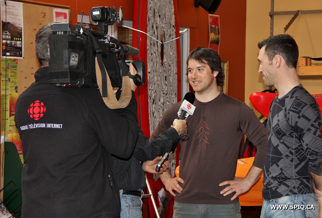
April 18, 2013, was held a press conference at the premises of Boréal Design to present the "Challenge ice dream," consisting of crossing the Northwest Passage sea kayaking
Firefighters Sebastien Lapierre and Olivier Giasson associated with the Quebec Firefighters Foundation for Major burned, try to meet this enormous challenge. The expedition "Ice Dream 2013" is to achieve a world first in the field of sports expeditions and sea kayaking
From Tuktoyaktuk, the 3500 km journey will end in Igloolik, all in less than 80 days (July-October). Since the two adventurers sail with one double kayak, steps are planned replenishment. Contacts have been established with various Inuit communities in the Arctic as well as the Canadian Coast Guard. The presence of the icebreaker Amundsen in the area during the summer will be of great help in case of a major glitch.
Based on the experience gained in the Greenland expedition 2010, two firefighters are confident of the success of this world first. The before, during and after the expedition can be followed via the website: www.revedeglace.ca
Have boat - please help with research... PLEASE PARTICIPATE WITH SECCHI APP
No time like the present to start something for the future
Dr Richard Kirby, a Plankton Biologist at Plymouth University and Project leader explains; "Many of the datasets that scientists rely upon today to tell us about long-term changes are 'citizen science' studies that were begun a few decades ago. Often we look back and wish we had already started monitoring something about the natural world - "if only we had started measuring 'x' ten years ago". Well our view was there is no time like the present to start something for the future. This is why we created the Secchi App and this Citizen Science project, to try to encourage data collection on the plankton and make data submission simple."
“One person recording a Secchi depth twice a month for a few years will generate useful data about their local sea,” Kirby says. “The more people that take part, the greater the project and the more important and valuable it will become to future generations.”
A recent study has suggested that the phytoplankton in the oceans that underpin the whole marine food chain has declined by 40% since the 1950s due to climate change. A team of scientists from Plymouth University, UK, have created a mobile phone app called Secchi and a Citizen Science project to encourage thousands of seafarers around the world to take part in a global study of plankton.
What does being a Citizen Scientist involve?
Taking part in this project is straightforward and simple.
When a seafaring citizen scientist is ready to use the app, the first step is to make a Secchi Disk (instructions are included). The small, white disk–made of plastic, wood or metal–is attached to a tape measure on one side and a weight on the other. You hold the tape measure and lower the disk vertically into the seawater, and as soon as it disappears from sight, you note the depth below the surface on the tape measure. This number, the “Secchi depth,” reflects the transparency of the water column, which is influenced by the number of particles present. The Secchi depth also tells scientists the depth to which light supports life in the water.
You use your smartphone and the Secchi app to obtain the GPS location and to enter the Secchi depth - a network connection isn’t required for this. It is very important that you use the Secchi app to obtain the GPS location when you measure the Secchi Depth. The Plymouth researchers receive the data as soon as you regain network connectivity. You can also upload photos and type in additional details like water temperature (measured by the boat) and notes on visual observations–say, a foamy surface, a plankton bloom or a flock of feeding sea birds. You can follow the data you collect, along with that of others, on the project's website.
The app is named after the inventor of the measuring disk, Father Pietro Angelo Secchi, who used it to gauge the cloudiness of the Mediterranean in 1865.
The amount of phytoplankton in the water column will vary seasonally, from place to place and annually. You may choose to set up a sample site and measure the Secchi Depth twice or more a month, or you may choose to make recordings on your travels, but avoid taking measurements in estuaries and areas of turbulent water. In whatever way you decide to take part, your help will assist the team in Plymouth to better understand the Oceans biology.
It is hoped that sailors wanting to get involved will begin as soon as possible with the experiments and continue indefinitely with collecting data. The team expect the Secchi Disk study to run for many years to come to create the world's biggest plankton survey. If enough data is generated (by just a small percentage of the world's seafarers), it will form a unique global database on the productivity of the oceans and how they are being impacted by climate change.
You can find out more at the project's websitewww.secchidisk.org which has some excellent tutorials.
You can participate in this project by making a Secchi Disk and using the free to download iPhone or Android ‘Secchi’ application.
Join in and make this the World’s largest, ongoing Citizen Science marine biological study.
"You don’t need a network connection to use Secchi. Secchi stores all the data until you get a mobile signal when it will ask you if you want to submit your data now, or wait until later."
RK, SV Odontella
The marine phytoplankton account for approximately 50% of all photosynthesis on Earth and, through the plankton food web that they support, they both underpin the marine food chain and play a central role in the global carbon cycle strongly influencing the Earth’s climate.
Living at the surface of the sea the phytoplankton are particularly sensitive to changes in sea surface temperature. A recent study of global phytoplankton abundance over the last century concluded that global phytoplankton concentrations have declined due to rising sea surface temperatures as a consequence of current climate change.
We need to know much more about these changes and you can help by making a simple piece of scientific equipment called a Secchi Disk and using the Secchi App.
FAQ
Where can I find out more about the Secchi App and this project?
Please see the two presentations for iOS and Android. Full instructions are also included with the App.
Why is this project important?
The phytoplankton underpin the marine food chain and so we need to know as much about them as possible.
Who can use the Secchi App?
Secchi App is for seafarers and scientists.
Is the Secchi App free?
The Secchi App is free and it is free to take part, however, we do ask you to make a Secchi Disk.
What is a Secchi Disk?
A Secchi Disk is a 30 cm, flat, white disk attached to a tape measure or a rope, and weighted from below by a small 200 g weight.
Do all Secchi Disks have to be 30 cm in diameter?
Yes. It is very important that everyone uses a disk that is the same size to standardise the survey.
What is the Secchi Disk used for?
A Secchi Disk is used to measure the Secchi Depth. The Secchi Depth measures the turbidity of the water, which is influenced by the amount of phytoplankton in the water column.
What are phytoplankton?
Phytoplankton - also called microalgae - are microscopic plant-like cells and they are the sea's main primary producers.
How do you use Secchi Disk to measure the Secchi Depth?
With the sun behind you, you lower the Secchi Disk vertically into the water from the side of your boat. The point at which the disk just disappears from sight is the Secchi Depth.
Can a Secchi Disk be made from anything?
Yes. A Secchi Disk can be made from any material so long as it is white, or it is painted white.
How often should I take a Secchi Depth reading?
You can take a Secchi Disk reading as often as you wish, every day, once a week, twice a month, or just occasionally.
Where should I take a Secchi Disk reading?
You can take a Secchi Disk reading wherever you wish at sea so long as you cannot see the seabed and you avoid estuaries.
Should I measure the Secchi Depth at a particular time of day?
Yes. The Secchi Depth should be measured between 10.00 hrs and 14.00 hrs.
Should I remove my sunglasses?
Yes. Please do not wear sunglasses when you measure the Secchi Depth.
Should I clean the Secchi Disk?
Yes. It is important to keep your Secchi Disk clean so that its visibility does not change.
Who will use the data I collect?
The data you collect will help scientists around the world to understand the phytoplankton.
What happens if I submit a Secchi Depth when I have no network connection?
In this case, the data will be stored on your phone as a pending reading. When you next get a network connection you will be prompted to either submit or delay until later.
How much data am I uploading to the database?
Secchi data occupies about 4 kb per reading. Photographs occupy about 50 kb.
How long will the project run?
This project begins now and continues indefinitely into the future.
Will this really be the biggest global marine survey?
Are you thinking about a Northwest Passage voyage?
Here are many good url links to important notices, directions and pilotage guides - don't leave home without them - I'd suggest printing out specific info and keeping them in an indexed/tabbed notebook binder for easy referencing underway - never trust your computer to stay up and running.
I.) National Geospatial Intelligence Agency
Nautical Publications Page (see NGIA sidebar - note pull-down menu at top to select specific items)
Pub. 111 - Pacific - Alaska (and more - see map above)http://msi.nga.mil/NGAPortal/MSI.portal?_nfpb=true&_pageLabel=msi_pub_detail&CCD_itemID=111&pubConstant=NGALOL 4. Pub 117 - Radio Navigational Aids Pub. 117 publication contains a detailed list of selected worldwide radio stations that provide services to the navigator. http://msi.nga.mil/NGAPortal/MSI.portal?_nfpb=true&_pageLabel=msi_portal_page_62&pubCode=00095. Sailing Direction Enroute Sailing Directions (Enroute) include detailed coastal and port approach information, supplementing the largest scale chart of the area. Each publication is subdivided into geographic regions, called sectors, which contain information about the coastal weather, currents, ice, dangers, features and ports, as well as a graphic key to the charts available for the area.
All Sailing Directions publications are updated via the Publication Data Update (PDU) process. For a Summary of Publication Data Updates, click here. Visit the Publications Data Updates page for more details on applying PDU files. Watch the PDU Demo video tutorial on how to apply a PDU patch, or download a 5.49MB zipped version here. Viewing/Downloading files
These are general instructions for downloading and viewing .pdf files: Locate the publication section you wish to download. Right click on the link. Select "Save Link As" (Navigator) OR "Save Target As" (Explorer). Specify where to save the publication on disk. Click on "Save". Open Adobe Acrobat Reader. Click on "File -- Open" to view the file. Click on "File -- Print" to print the file
7. USCG Light List Each volume corresponds to a different regional area and contains more complete information on each aid to navigation than can be conveniently shown on charts. This publication and the data contained within it is maintained and published by the USCG.
Pub 150 contains the location and physical characteristics of, and the facilities and services offered by major ports and terminals world-wide (approximately 3700 entries), in a tabular format. Entries are organized geographically, in accordance with the diagrams located in the front of the publication. 4MB PDF updated - http://msi.nga.mil/MSISiteContent/StaticFiles/NAV_PUBS/WPI/Pub150bk.pdf
II.) US Notice to Mariners The US Notice to Mariners provides timely marine safety information for the correction of all US Government navigation charts and publications from a wide variety of sources, both foreign and domestic. To ensure the safety of life at sea, the information published in the Notice to Mariners is designed to provide for the correction of unclassified nautical charts, the unclassified NGA/DLIS Catalog of Hydrographic Products, United States Coast Pilots, NGA List of Lights, USCG Light Lists, and other related nautical publications produced by NGA, NOS and the USCG.
The US Notice to Mariners corrects NGA and NOS charts using information collected from many sources, among them the Local Notice to Mariners published by the nine US Coast Guard Districts. The US Notice to Mariners will contain only those chart corrections of interest to ocean-going vessels.
The Pilotage Foundation has offered limited pilotage advice for yachts sailing in Arctic Waters for some years. Faroes Iceland and Greenland now in its 3rd edition, was introduced in 1995, while Norway, which followed in 2007, includes chapters on Svalbard and Jan Mayen as well as the Norwegian coastline north of the Arctic Circle. More yachts are tending to explore further north from the Atlantic and Pacific regions than hitherto. This publication seeks to consider the implications for yachts heading north into the Arctic oceans from the Pacific and the Atlantic. It has only been possible due to the considerable in depth advice offered by highly respected yachtsmen with considerable first hand experience of independent passage making in remote areas where ice is generally an ever present threat. The Pilotage Foundation is indebted to Jane Russell (a circumnavigator and also author of our book Atlantic Crossing Guide) who has consulted widely and in depth to present this publication. Those who have contributed so willingly are recorded below and I warmly thank them all for their contributions and in being prepared to share their experiences with a wider public. This is not a pilot book and it is not our intention to entice skippers north who are not fully mentally and physically prepared for the task – though we hope that some armchair sailors will gain some insight into the conditions faced by those who are drawn to northern waters. Planning and timing are essential facets of arctic sailing and we hope this document will help with preparations. All should note the Caution for yachts sailing in the Arctic, as shown below.
- Martin Walker Hon Director RCC Pilotage Foundation March 2011
Standing by while cruising in a tropical 'paradise'...
Doug
BTW - Pay particular attention to voyaging through the Bering Sea, Aleutian Islands and Gulf of Alaska - very severe storm weather unlike anything you may have ever experienced will be crossing this region... I'll provide in the near future a Blog page with weather links to help you know of advancing weather. Best advise - make good early progress through the Arctic so you cross this geographical region as soon as possible - early September - passing in the late Fall - late September or October - will likely prove harder on you, your crew and vessel than anything to date - you have been warned! Prudent mariners will take this advise to heart!
The information provided in this guide should be used together with all other relevant information, as required by law, standards and good seamanship practices.
User selected map display: Hamlets, weather zones and ice zones
Description
The Arctic Voyage Planning Guide (AVPG) is intended as a strategic planning tool for national and international vessels traveling in the Canadian Arctic. It draws together regulatory information pursuant to the Canada Shipping Act, 2001 and the Charts and Nautical Publications Regulations, 1995 as well as complementary data and information from Canadian federal departments with mandates to support safe navigation. The intent of the AVPG is to provide a comprehensive digital planning tool for mariners considering an Arctic voyage.
The mariners remain responsible for navigational decisions and safety of their ships. The information provided in this guide should be used together with all other relevant information, as required by law, standards and good seamanship practices.
The AVPG is not intended to replace official carriage information or products provided from Canadian sources. This AVPG digital version will be maintained with Notices to Mariners as needed but in case of disparity, the information contained in official publications will prevail.
Layers and Data
This map is composed from the following services. Availability of layers and data is constrained to the supported interfaces available. Please refer to our Web Map Services page to learn more on how to use the supported interfaces.
The youngest ever sailing crew conquered Northwest Passage!
Entering the Pacific Ocean through the Bering Strait on the 19th of September 2006 the crew of S/V "Stary" closed the symbolic gate of the Northwest Passage. At the same time, with the average age of 25, the crew of S/V "Stary" became the youngest ever sailing team in the history of one of the most difficult sailing routes in the world. Deck by deck with S/V "Stary", and another Polish yacht - S/V "Nekton" - both have completed the Passage. Both yachts became the first Polish sailing yachts to have ever sailed through the legendary Northwest Passage. ROUTE Yacht STARY Source: www.amundsen.pl
"Old" with us for a long time. Performed very well during our last trip around South America. Now, can he cope with the Arctic ice - Dominik Bac, author of the expedition.
GPS - Global Positioning System - a satellite positioning system coordinates. The GPS receiver allows you to determine the boat's position to within several meters. The receiver also has a catalog of electronic maps. The device is also connected to the radar, which allows for accurate navigation in difficult and unfamiliar waters. Type: Garmin GPSMAP 180 - 12 channels; funds - Garmin 126, Garmin 48, Garmin 38 - manual used for navigation on the glider and the land expedition.
Radar - warns of the dangers of navigation and obstacle detection facilitates the fairway. Will also be used for navigation on the misty waters of Greenland, where the icebergs are not uncommon. Type: SIMRAD RA 30; antenna closed, 1.5 feet diameter, radius 24 nm.
NAVTEX - receiver meteorological and navigational warnings - on a continuous basis provides the latest information on weather conditions and expected changes: col situation, the strength and direction of wind, precipitation, etc.. It shall also inform the latest developments and dangers in navigable waterways. Receives information about the DSC signals. Type: Target NAVTEX PRO-Plus NASA MARINE.
COMMUNICATION EQUIPMENT
Transceiver HF / VHF Transceiver 100W working at all frequencies for both amateur and sea and air. Under favorable propagation conditions provide for communication with global reach. When connected to a computer allows you to receive weather and television faximili RTTY. Type: I-COM 706 mk II
IRIDIUM - Marine Satellite radio. A satellite phone is the hardware that allows you to communicate with any telephone subscriber from any point on the globe. The covers 100% of the earth's surface including the polar regions. With it's easy to summon help and contact with the boat. The phone also has the ability to upload data via a special e-mail program. Telephone number: 0088 1631573710 Type: SAILOR SC 4150
VHF (VHF) - standard equipment for communications at sea - contact with other units and the port authorities. FM-each equipped with a system DSC (Digital Selective Calling) combined with the GPS used to call for help. Type: Skanti VHF 1000 P DSC, power: 25 W
SAFETY EQUIPMENT
EPIRB - to call for help on the frequency of aerial and satellite imagery - a very strong signal containing the identification number of the yacht is received by all units nearby and satellite. Additionally equipped with a strobe light. Type: Sailor SARSAT 406 MHz satellite EPIRB, number: 261 003 340
Radar transponder - a device used to call for help. Search And Rescue Transponder (SART) is a radio transmitter and receiver 9GHz. Upon receipt of any radar pulse 9GHz x-band, SART immediately transmits a signal clearly identifies the individual at risk of a radar screen - enables precise location of the yacht and quick help. Type: SAILOR SART 9.2 - 9.5 GHz.
ENGINE
Type - URSUS4410
Power - 59.5KW
Turnover - 2350obr./min.
Will Converter - 3
CREW Source: www.amundsen.pl Stage I (Poland - Greenland)
Captain: Colin Jendroszczyk
Crew: Mark Bonczar, Anne Jakubiec, Andrew Kolon, Michal Michalik, Aleksander Nowak, Marek Sobieski, Tom Szewczyk (Iceland - Greenland)
Stage II (Northwest Passage)
Masters of: (in order of running) Dominik Bac, Jacek Wacławski, Slawek Skalmierski
Crew: Konstantin Kulik, Agnieszka Strużyk, Thomas Szewczyk
Colin Jendroszczyk , b. 1982 Participant trip around South America, the navigation officer and a good sailor. Swam nearly 30,000 miles of sea. Film and theater lover, windsurfing and paragliding.Responsible for the preparation of navigational expedition. Author's website Nwpass.pl. Favorite Quote: "one in a million chance goes up as one to ten." A student of the Academy of Economics in Katowice.
Mark Bonczar , b. 1979 Yacht Skipper, participated in a cruises on the Baltic, the North Sea and the Aegean. Skier, a lover of the Tatra Mountains, painting, literature, and the Beatles.Doctor of Medicine.
Anne Jakubiec
teacher by profession.Instructor Scout Scoutmaster extent, the organizer and commander of many camps and trips. Secretary of the Department of Children's Friends Association Boat-Polesia, organizer of such colonies and events for children with disabilities, including therapeutic activities. Passion: sailing - after all, born and has always lived in Lodz! QNT Northwest Passage Jubilee Voyage 2006 - it was her dream come true of the "expedition life" (previously only sailed on the Baltic Sea).
Andrzej Kolon , b. 1981 Under the sails came to the shores of five continents, was the research stations on Spitsbergen and Antarctica. He has travel to Ecuador, Argentina and Brazil. An avid skier, the soul of the company and an excellent companion in emergency situations. Class 1 radio operator, call sign SQ9MLJ.Student Silesian University of Technology.
Michal Michalik , b. 1982 His passion is snowboarding, windsurfing and dabbled otniarstwo. An indispensable member of the crew, has an excellent sense of humor and knows how to deal with any situation. He studied at the Faculty of Economics at the University of Economics in Katowice.
Alec Smith
Student artwork Academy of Music. Karol Szymanowski - the Department of Composition, Interpretation, Education and Jazz. Yacht Skipper, he participated in several sea voyages, including to Spitsbergen with the captain. Andrew Beżańskim in 2004. In a sea of ocean sees possible inspirations.
Marek Sobieski , b. 1954 Entrepreneur (304th position among the 500 largest Polish enterprises), loves the movement and nature.Captain of the yacht from 1977, Polish champion Tony One class of 1972, two-time participant in the race for the Cup Polonaise loners.He s / s Asterias voyages Havana-Swinoujscie and Sydney-Montewideo, around Cape Horn (second prize Voyage of the Year '88). Mountain bike enthusiast (multiple participant in the eight-day race in pairs Addidas Chellenge Bike Transalp 2000-2005) and Hobbie Cat catamarans sports (racing participant Amber Cup 2004).Blessed is the man, the father of three sons, 4 months Magdusi grandfather.
Thomas Szewczyk , born. 1986 Sea Yacht skipper for many years on boats sailing competitively, is a master of Silesia in class Europe. His passion is skiing and windsurfing.The tactician trip and prepare hardware. Class 1 radio operator, call sign SQ9MLS. He participated in the expedition Scandinavia Around 2004, which reached the entrance to the Channel Białomorsko-Baltic on Lake Onega. Student of the Faculty of Mechanical Engineering of the Technical University in Gliwice.
Dominik Bac , b. 1979, originator and author of the expedition Northwest Passage Jubilee Voyage 2006 (together with Jack Wacławskim and Slawek Skalmierskim) honored with the prestigious "Hindrances" - a dream for many years connected with the Arctic, mountains and areas podbiegunowymi. Co-organizer, participant and photographer expedition "Cape Horn Antarctica Expedition 2002/2003". Organizer land expedition to the volcano Cotopaxi (highest active volcano in the world 5896 meters above sea level) and the interior of South America (Colombia, Amazonia, Peru, Ekwadorm, Chile, Argentina, Brazil). Isolated completed the expedition "Trans-Asia 2000" and "Himalayan kingdom of Ladakh and Nepal 2001 '. The main organizer of the expedition "Dakar 2004". President and founder of the 'Group Outdoor "- the organizer of expeditions and sea voyages. Lecturer navigation on the sailing ship "Pogoria". This leads to the end of the project "impossible". As a pilot of foreign tourists visited half of Europe.Among his passions outside of sailing, include mountain climbing, skiing, caving and globtrottering and recently diving. A graduate of the Academy of Physical Education.
Jacek Wacławski , b. 1981 Sailor of the Year award winner in 2003 and the Colossus of 2003, the most prestigious award travel in Poland. The world's youngest captain to sail under sail to the shores of Antarctica. There is no impossible for him-as he says, "You just have to swim." He was the initiator and main organizer of the expedition "Cape Horn - Antarctica Expedition 2002/2003", around South America and Cape Horn. Is the author of motivational training. Contributor Northwest Passage expedition project Jubilee Voyage 2006 honoree prestigious "Hindrances." Student Medical University of Silesia, working in the Laboratory of Experimental Cardiology, Silesian Center for Heart Diseases in Zabrze.
Slawek Skalmierski , b. 1979 Student Silesian University of Technology. During the expedition Cape Horn Antarctica Expedition 2002/2003 winner of the Cotopaxi volcano in Ecuador. A specialist in technical matters and electronics. Organizer and participant of expedition Dakar 2004. A man of any special tasks.Since 1994, the year the glider. Among his passions can be found, such as skiing, gliding, ultralight trikes, and windsurfing.Contributors Project expedition Northwest Passage Jubilee Voyage 2006 honored with the prestigious "Zawada"
Konstantin Kulik
Wielkopolska Graduate School of Radio Television and Film, the listener National Film School in Łódź. Developer TVP television programs, documentaries, commercials and music videos. With Love: explorer, sailor, photographer and cook. His motto - "The harder, the better."
Agnieszka Strużyk , b. 1982 Her passions - is windsurfing, sailing and snowboarding. Yacht Skipper, took part in the cruises in the North Sea, the Norwegian and Baltic Sea. Schedule expedition.Student of the Faculty of Architecture of the Technical University of Silesia.
QNT Northwest Passage Jubilee Voyage 2006 started in Greenland on 15th of August 2006 and was dedicated to commemorate 100th anniversary of the pioneer Roald Amundsen's expedition, Norwegian explorer, who became the first person to sail entire length of the Northwest Passage in the years 1903 - 1906.... read more in the press release
From Greenland S/V "Stary" was accompanied by the second polish yacht - S/V "Nekton" - commanded by Capt. Tadeusz Natanek with the Polish crew originating from Canada, who also decided to sail the Northwest Passage. Both crews sailed the waters from the Atlantic to the Pacific Ocean helping each other. Joint success of both crews was accomplished by symbolic, deck by deck, passing over Point Barrow, the farthest northern point of the USA whose passing meant successfully leaving the vastness of Arctic ice behind. Next, both yachts went south through the Chukchi Sea to the Bering Strait ending the main part of the expedition there.
Following the steps of Roald Amundsen's route the members of QNT Northwest Passage Jubilee Voyage 2006 also explored the land. They were climbing the Greenland mountains, paragliding over the Arctic ice and visiting the whale hunters' village located on Cross Island. They were also diving in the wreckage of "Maud" the ship that originally belonged to the Norwegian explorer. During the six weeks long expedition a documentary titled "Searching for the legend" was produced. It focuses on the life of Norwegian discoverer as seeing by contemporary eyes.
"Sailing the Northwest Passage only in one season and in such a sort time proves a huge success. It also demonstrates perfect planning and expresses determination of the crew who try to make the most of good weather forecasts to the very last day", says Capt. Wojciech Jacobson, one of the first Poles, who in the years 1985-1988 successively sailed the Northwest Passage together with Ludomir Maczka in the expedition organized by known explorer Janusz Kurbiel.
"I followed all the steps of the expedition and I was entirely emotionally engaged in it. I admire them for the ability to find the time for climbing, diving and paragliding. Congratulations to all of them! Professional climbers know well that climbing down the top of the mountain is equally difficult as to climbing up. I wish them happy and safe voyage while coming back from north top end across the Bering Sea and the Pacific", adds Jacobson.
The jubilee sailing of the Northwest Passage has closed the main part of the expedition. However, it was not the end of the QNT Northwest Passage Jubilee Voyage 2006 expedition itself whose aim was to circumnavigate North America. From Vancouver the next part of expedition begun. This time, on the way to Miami, the young crew explored San Bias Archipelago - the territory settled by The Kuna Indians. Next, they sailed through the Panama Canal in order to reach Colombia from the Darien Narrow called the "The Pole of the jungle". In Colombia the sailors were exploring Sierra Nevada de Santa Marta, the world's highest seaside peaks.
About Northwest Passage
The Northwest Passage is a sea route connecting the Atlantic and Pacific Oceans through the Arctic Archipelago of Canada. John Cabot was the first explorer who was trying to find the way through the Northwest Passage. He then was followed by Martin Frobisher, John Davis, Henry Hudson, William Parry, Robert McClure (who discovered the first NW Passage) and Sir John Franklin Expedition of 126 men and two ships forever lost. Only Roald Amundsen, famous Norwegian polar explorer who first reached the South Pole, was the first was lucky enough to sail the entire Passage in the years 1903-1906.
About QNT Northwest Passage Jubilee Voyage 2006
QNT Northwest Passage Jubilee Voyage 2006 is the second polar expedition organised by members of Group Outdoor Association from Gliwice in Poland. During the previous voyage organized in 2002/2003, the same yacht S/V "Stary" lead by Capt. Jacek Wacławski rounded South America around Cape Horn and sailed down to the Polish Antarctic Station - "Henryk Arctowski" reaching position 63°03'S, 60°44'W at the King George Island. Achieving that S/V "Stary" became the second Polish sailing yacht that had ever sailed so far to the South. This expedition was then awarded The Kolosy Award for the sailing achievement of the year 2003.
The main organizers of the expedition are sailors and travellers from Group Outdoor Association: Dominik Bac, Sławek Skalmierski, Jacek Wacławski and Agnieszka Strużyk, Tomasz Szewczyk and Konstanty Kulik, film director. KUDOS on your accomplishment!!!
Photos of the Day: The Northwest Passage in Four Weeks
December 4 - Pt. Richmond
The normally difficult east-to-west route through the Northwest Passage was relatively easy this year, allowing the 42-ft steelStary to complete the trip in four weeks. Photo Dominik Bac
The crew of the Polish-flagged Stary, the youngest crew to traverse the infamous Northwest Passage - and the first boat to do so flying the Polish flag - sailed under the Golden Gate Bridge on Saturday to a warm welcome from the local Polish community, as well as many others who were impressed with their recent accomplishment. The crew of 20-somethings embarked on their expedition, which took them only four weeks (many boats wait for years for the ice to clear enough to make the trip), to commemorate the 100-year anniversary of the first successful crossing by Roald Amundsen of what many consider to be the world's most difficult sailing route.
The young crew of Stary are thrilled to be in the 'tropics' of San Francisco Bay after crossing the Northwest Passage. Photo Latitude/LaDonna
Stary is being hosted by Brickyard Cove Marina, and the fun-loving crew plan on exploring the Bay for a week or so before they head south. Check out the January issue of Latitude 38for the scoop on their trip, which included diving under icebergs, camping on top of icebergs, climbing up icebergs and flying over icebergs.


 The amount of phytoplankton in the water column will vary seasonally, from place to place and annually. You may choose to set up a sample site and measure the Secchi Depth twice or more a month, or you may choose to make recordings on your travels, b


 tutorial on how to apply a PDU patch, or download a 5.49MB zipped version


