Apparently Carlson didn’t use the Internet much in the 1940s.
The whole thing is a conspiracy. Skeptics traveled back in time and altered the newspaper records to make it look like there was a meltdown occurring. And GISS did the same thing with their temperature records.
Hey! If you are into melting ice, and it appears you are, Steven has kindly supplied an entire section on it.
None of the satellite data from 1940 contradicts the Russian’s claims.
My experience is that scientists now are far more likely to be dishonest than newspapers were 50 years ago.
You must have missed Obama’s science adviser John Holdren, when he said that ice-free winters follow shortly after ice-free summers.
Where did you get the idea that science meant focusing on only one statistic, and that looking at any other data is prohibited?
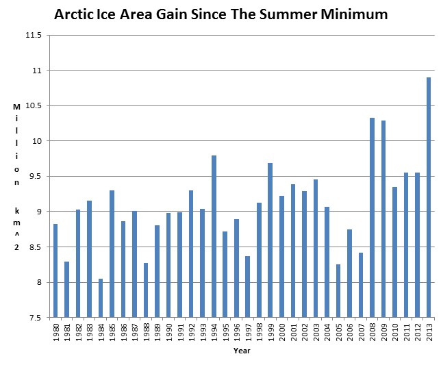
Ice extent today is almost identical to the same day in 1994.
1979 is a wonderful year for alarmists to start Arctic ice records, since it was the coldest winter in history.
...
http://stevengoddard.wordpress.com/2013/02/12/most-ice-gain-ever-recorded/
Mini Ice Age
This is quickly turning into the "winter of our discontent" for some Minnesotans.
Yes, it's a real winter this year.
As thermometers plummet again we endure yet another day of sub-zero wind chills this month. The busy weather week will peak Friday, with yet another round of "plowable" snow for much of Minnesota.
In this edition of Updraft we look at how February is turning into a mini "ice age" and track the next winter storm(s) heading our way.
A "normal" winter?
What a concept.

Sun Dogs in Mankato this morning
Image: Matt Lutz
14 of 19 days so far this month with snowfall at MSP Airport
10.9" February snowfall total so far at MSP
February 2011 last month we tallied more snow at MSP (16.1")
31.3" season snowfall total so far at MSP
+15.6" vs. last winter
66 mph wind gusts at Grand Marais harbor at 6:56am this morning!
DLH: GRAND MARAIS,MN (GNA) ASOS reports gust of 57.0 knots from NNW @ 1256
So This is Winter:
Just when you thought it was safe to declare winters perpetually wimpy in Minnesota.
February 2013 is going down in the books as a rigorous winter month. This is now the snowiest month in 2 years in the metro.
Temperature trends this (meteorological) winter have taken a nosedive. Check out the monthly average temperature trend since December.
MSP Airport
December +3.7F
January +1.3F
February -1.7F
As we head toward the last week February, it looks as if we're poised to wrap up meteorological winter about +1.1F overall in the metro. That's respectably close to an "average Minnesota winter."
We've shoveled 31.3" of snow so far this winter in the metro...and 70.3" in International Falls.
And we're not even close to done yet.
Next Winter Storm Takes Aim:
The next system in our February snow blitz is on the way.
This is a panhandle hooker, winding up in the Oklahoma Panhandle Thursday morning and shooting north into Iowa by Friday.
Our arctic air dome overhead will assure all snow with this one. That's good news for us as forecasters, because at least we should realize the full snow potential with this system.
The Euro (.54") & NAM (.46") are the leaders with liquid precip predictions with this one. The GFS suggests a weaker system with just .26" liquid.
Cold air should bring a "drier" snow...with snow:water ratios as high as 15:1.
It's still early, but if the Euro & NAM solutions pan out...that should translate into a wide area of 4" to 8" snowfall potential across the southern half of Minnesota by late Friday night.
The system will peak in strength over Kansas, Nebraska and western Iowa.
Anywhere from 12" to 20" of snow could fall in these areas...that's great news for the heart of the Midwest Drought.

It won't soak into parched (still frozen) soils, but the melt will help boost river levels this spring.
That's the good side of a heavy winter snowfall.
A second incoming storm brings another chance of snow...possibly mixed with rain and ice early Sunday night into Monday of next week.
That would make our 9th storm this month by my count.
This February, the weather hits just keep on comin'!
Want some good (as in warmer) news?
The ray of hope in the long range forecast is the maps are hinting at a major thaw potential after about March 5th or 6th. Could temps in the 40s, melting snow and dripping icicles be in our future?
Stay tuned.
![seaice.recent.arctic[1]](http://wattsupwiththat.files.wordpress.com/2013/02/seaice-recent-arctic1.png) Source: Cryosphere Today – Arctic Climate Research at the University of Illinois
Source: Cryosphere Today – Arctic Climate Research at the University of Illinois![cryo_latest[1]](http://wattsupwiththat.files.wordpress.com/2013/02/cryo_latest1.jpg)
![seaice.recent.antarctic[1]](http://wattsupwiththat.files.wordpress.com/2013/02/seaice-recent-antarctic1.png)
Arctic now; Winter Storm Watch ahead; Snowiest month in 2 years
Sun Dogs in Mankato this morning
Image: Matt Lutz
January +1.3F
February -1.7F