Wednesday, September 4, 2013

Fat Lady given 15 minute call out notice - COUNTING DOWN TO SEASONAL TIPPING POINTS

http://stevengoddard.wordpress.com/2013/09/04/melt-season-almost-over/


Melt Season Almost Over

Green shows ice gain over the last two days. Red shows ice loss.
ScreenHunter_179 Sep. 04 04.34

THE LOWS ARE COMING... BATTEN DOWN THE HATCHES... PREPARE FOR STORM WEATHER.


Storm Warning Flags
penantpenant
penant
flagflag
flag
Small Craft Warning
21-38 mph
(18-33 kts)
Gale Warning
39-54 mph
(34-47 kts)
Storm Warning
55-73 mph
(48-63 kts)
Hurricane Warning
74+ mph
(64+ kts)
Beaufort Scale
FORCE
DESC
MPH
EFFECTS
0
Calm
0-1
Land- Smoke rises vertically
Water- Like a mirror
1
Light Air
1-3
L- Rising smoke drifts
W- Small ripples
2
Light
Breeze
4-7
L- Leaves rustle
W- Small wavelets, wind fills sail
3
Gentle Breeze
8-12
L- Light flags extend
W- Large wavelets, sailboats heel
4
Moderate Breeze
13-18
L- Moves thin branches
W- Working breeze, saiboats at hull speed
5
Fresh Breeze
19-24
L- Small trees sway
W- Numerous whitecaps, time to shorten sails
6
Strong Breeze
25-31
L- Large tree branches move
W- Whitecaps everywhere, sailboats head ashore, large waves
7
Moderate Gale
32-38
L- Large trees begin to sway
W- Much bigger waves, some foam, sailboats at harbor
8
Fresh
Gale
39-46
L- Small branches are broken from trees
W- Foam in well marked streaks, larger waves, edges of crests break off
9
Strong
Gale
47-54
L- Slight damage occurs to buildings
W- High waves, dense spray, visibility affected
10
Whole
Gale
55-63
L- Large trees uprooted, considerable building damage
W- Very high waves, heavy sea roll, surface white with spray and foam, visibility impaired
11
Storm
64-74
L- Extensive widespread damage
W- Exceptionally high waves, small to medium ships obscured, visibility poor
12
Hurricane
74+
L- Extreme destruction
W- Waves 40+', air filled with foam and spray, visibility restricted
FORECAST VALID...SATURDAY 7 SEPTEMBER 2013 ANALYSIS CONFIDENCE...MODERATE. 
SYNOPSIS...A LARGE STRONG LOW IN THE CENTRAL BERING SEA WILL MOVE OVER THE ALASKAN WEST COAST LATE TUESDAY THEN SLOWLY WEAKEN WEDNESDAY THROUGH FRIDAY. ANOTHER LOW WILL SHIFT NORTH OVER INTERIOR ALASKA ON SATURDAY. A BROAD AREA OF HIGH PRESSURE WILL REMAIN OVER THE NORTHERN CHUKCHI AND BEAUFORT SEAS THROUGH SATURDAY. 

FORECAST THROUGH SATURDAY...CHUKCHI SEA...EAST NORTHEAST WINDS WILL REMAIN MODERATE TO STRONG THROUGH THURSDAY WHEN THE WINDS WILL BECOME MORE EASTERLY AND START TO DECREASE IN STRENGTH. THE STRONG WINDS WILL AID IN BREAKING APART HIGHER CONCENTRATION AREAS OF ICE REMAINING NEAR THE SOUTHERN ICE EDGE. THE NET ICE EDGE MOVEMENT WILL BE 20 TO 30 NM TO THE WEST THROUGH SATURDAY... WITH HIGHER CONCENTRATION AREAS OF ICE SPREADING OUT INTO AREAS CURRENTLY OCCUPIED BY 1 TO 3 TENTHS OF ICE COVER AND OPEN WATER AREAS. 

FORECAST THROUGH WEDNESDAY...BEAUFORT SEA...EASTERLY TO NORTHEASTERLY FLOW IS EXPECTED TO PERSIST OVER THE BEAUFORT SEA ICE EDGE THROUGH SATURDAY. THE OVERALL NET ICE EDGE MOVEMENT WILL BE MINIMAL... HOWEVER THE HIGHER CONCENTRATION ICE AREAS ARE EXPECTED TO HAVE A NET SHIFT OF 20 TO 30 NM TO THE WEST SOUTHWEST THROUGH SATURDAY.


Canada Ice Forecasts


Foxe Basin

Very close pack first-year ice.
Outlook for June…Becoming close to very close pack ice after mid-month.
Outlook for July…Close to very close pack ice except open drift or less ice over the southeastern section after mid-month.
Outlook for August…Close to very close pack ice except open drift or less ice over the eastern and northern sections during the third week.
Outlook for September…Ice melting completely during the third week then open water.

Arctic EventsEarliest Date (1968-2012)Latest Date (1968-2012)Median (1981-2010)Outlook
Foxe Basin AreaOpen waterSepOct20 Sep20-22Sep

Pond Inlet

Consolidated first-year ice.
Outlook for July…Ice fracturing during the third week then very close pack ice.
Outlook for August…Becoming open drift or less ice early in the month. Ice melting completely during the first week then bergy water.
Outlook for September…Bergy water.

Admiralty Inlet Northern

Consolidated first-year ice.
Outlook for July…Ice fracturing near mid-month. Ice melting completely at the end of the month.
Outlook for August…Bergy water.

Lancaster Sound

Very open to open drift first-year ice. Trace of old ice over the eastern section.
Outlook for July…Open drift or less ice.
Outlook for August…Ice melting completely during the second week then bergy water.
Outlook for September…Bergy water.

Prince Regent Inlet

Consolidated first-year ice.
Outlook for July…Ice fracturing early in the month then close to very close pack ice.
Outlook for August…Becoming open drift or less ice early in the month. Ice melting completely after mid-month then bergy water.
Outlook for September…Bergy water.

Arctic EventsEarliest Date (1968-2012)Latest Date (1968-2012)Median (1981-2010)Outlook
Pond Inlet AreaFracture10 July19 Aug23 July19-21 July
Bergy water25 July12 SepAug6-8 Aug
Admiralty Inlet - Northern AreaFracture29 JuneAug21 July14-16 July
Bergy water17 July12 SepAug29-31 July
Lancaster Sound AreaFracture12 JuneAug6 JulyAlready fractured

Tuktoyaktuk Peninsula

Consolidated first-year ice.
Outlook for July…Ice fracturing early in the month then open drift or less ice during the first week. Ice melting completely during the second week then open water.
Outlook for August…Ice free.

Mackenzie Bay to Cape Bathurst

Consolidated first-year ice.
Outlook for June…Consolidated ice. Ice melting completely in Mackenzie Bay after mid-month.  Ice fracturing north of Mackenzie Bay during the last week then melting completely at the end of the month.
Outlook for July…Ice fracturing east of Mackenzie Bay early in the month then open drift or less during the first week. Ice melting completely during the second week then open water.
Outlook for August…Ice free.

Cape Lisburne to Point Barrow

Very close pack first-year ice.
Outlook for July…Close to very close pack ice becoming open drift or less ice during the third week.
Outlook for August…Ice melting completely early in the month then open water.
Outlook for September…Ice free.

Amundsen Gulf

Consolidated first-year ice.
Outlook for July…Ice fracturing early in the month then very close pack ice. Becoming open drift or less ice during the last week.
Outlook for August…Ice melting completely during the second week then open water.
Outlook for September…Ice free.

Larsen Sound

Consolidated first-year ice.
Outlook for July…Ice fracturing during the fourth week.
Outlook for August…Close to very close pack ice becoming open drift or less ice during the third week.
Outlook for September…Ice melting completely during the second week then open water.

Peel Sound

Consolidated first-year ice.
Outlook for July…Ice fracturing during the fourth week.
Outlook for August…Close to very close pack ice becoming open drift or less ice during the second week.
Outlook for September…Ice melting completely during the first week then open water.

M’Clure Strait

Consolidated first-year ice with areas of 2 tenths of old ice.
Outlook for July…Ice fracturing over the western section during the first week and over the eastern section the third week.
Outlook for August…Becoming open drift or less ice during the first week.
Outlook for September…Open drift or less ice.

Arctic EventsEarliest Date (1968-2012)Latest Date (1968-2012)Median (1981-2010)Outlook
Tuktoyaktuk Peninsula AreaFracture18 June17 July1 July30 June-2 July
Mackenzie Bay to Cape Bathurst RouteOpen water18 June27 Sep26 July21-23 July
Mackenzie Bay to Prudhoe Bay RouteOpen drift or less4 July20 Sep13 Aug19-21 July
Prudhoe Bay to Point Barrow RouteOpen drift or less11 JulySep13 Aug29-31 July
Close pack (refreeze)N/AN/AOct9-11 Oct
Cape Lisburne to Point Barrow RouteOpen drift or less10 JuneSepAug18-20 July
http://www.ec.gc.ca/glaces-ice/9CD04FB5-11DE-4DD3-A08D-9EF66DA43518/20130603_otlkare_summer2013.pdf

Where and when do you think it is going to freeze-up? (click graphic for larger size image)


Tuesday, September 3, 2013

Whats with icebreaker going to DANGEROUS WATERS jetskiers location then departing - RESCUE OR MEDICAL EMERGENCY?

Photo from DW's FB... imagine a sea full of ice coming at you with frozen jetskis and no place to hide... INCOMING!!!


20130904 UPDATE
  • Paul McGregor

    According to Steve Moll's wife, who had talked with Steve via sat phone, the CCG picked them up yesterday. Everyone is OK. They were not able to proceed due to weather. They were just South of Bellot Strait.

    Wind northwest 20 knots diminishing to light early this afternoon then becoming southeast 15.
    Temperatures near minus 1.
    Chance of snow.


It is now 20130903 1945 hrs and it appears the CCGS SIR WILFRID LAURIER has just departed the Jetskiers location as south of the western entrance to Bellot Strait - RESCUE OR MEDICAL EMERGENCY?

No new tracker information - if there was a 9-1-1 message it might have been masked by the admin. Here is the last SPOT GPS TRACKER MESSAGE


Facebook url: https://www.facebook.com/DANGEROUSWATERSTV

DangerousWatersTV SPOT Tracker remains online


Comments please...


http://www.thespec.com/news-story/4068357-jet-ski-crossing-of-northwest-passage-fails/

Jet ski crossing of Northwest Passage failsByBob Weber

GJOA HAVEN, Nunavut - An American adventurer is promising to try again after his plan to cross the fabled Northwest Passage on a Jet Ski went the way of so many Arctic dreams — cold, wet and stuck in the ice.

"Humbled, 110 per cent," said Steve Moll on Friday from his warm and dry room in Gjoa Haven, Nunavut, after being plucked out of the freezing waters of the Franklin Strait by a coast guard icebreaker.

"We'll come back. But we'll just have a little bit more respect for the environment."

Moll is the leader of a seven-man team attempting to circumnavigate the globe on personal watercraft. Their adventures are chronicled on a U.S. reality show called "Dangerous Waters" and in the first two season they made it up the west coast of North America, around the top and as far east as Inuvik, N.W.T.

This season, the goal was to cruise the passage, round the southern tip of Greenland, jump off Iceland and the Faroes and ultimately rev their engines up London's Thames River.

It started well enough. After extensive briefings from the Canadian Coast Guard on weather and ice conditions, the four specially equipped Jet Skis and a nine-metre fuel boat took off from Inuvik in early August.

They made great time through the Amundsen Gulf, cruising up to 27 hours at a stretch through the long northern days and stopping only four or five hours to catch some sleep and a hot meal.

But by Cambridge Bay, midway through, the Arctic weather was starting to go south.

Heavy winds delayed their departure until about Aug. 20 and again stranded them on Jenny Lind Island for four days. Still, they pushed on to Gjoa Haven.

After five days of preparations, they left Gjoa Haven on about Aug. 27 — and headed into the teeth of some ugly conditions.

"It had been snowing. It was freezing cold. The wind had whipped up," Moll said.

After only about 70 kilometres, they were forced to hole up overnight on another small island. Light winds the next day enabled them to make it farther up the coast of Boothia Peninsula, where they spent a night in a polar bear research cabin.

A good thing, too. During the night, a bear came through and tore up the expedition tent the crew had erected.

"That was concerning," said Moll. "Now I've got seven guys in my crew and one tent I can put four in. Things were starting to deteriorate."

Last weekend, the team mounted a push to get through the Bellot Strait, a tiny sliver of water between the peninsula and Somerset Island that was to be the gateway into the eastern Arctic and calmer seas.

"We got about 15 miles short of Bellot and the ocean was literally freezing beneath us. The ocean starts forming little pancakes about the size of a quarter and there's millions of them underneath you. It's like you're riding on top of a Slurpee."

Ice clogged their engines and covered their drysuit-clad bodies.

"We were covered in suits of armour, of ice."

Again, they ducked into the lee of an island, planning to break for the strait at first light. They spent the night huddled in sleeping bags, crammed into the fuel boat "like sausages in a package," sheltered by a tarp from the falling snow.

"We wake up in the morning and we're locked in the ice. The ice has moved in, it's completely around all the Jet Skis and the boat."

Moll consulted with the coast guard and the weather news wasn't good. More snow, cold and 40-knot winds. And now, one of the fuel containers in the boat began leaking, adding to the water that had accumulated from two days of snow.

"The bottom line is we're there stuck in the ice and the weather's getting worse and worse and the crew and I started to talk about what could happen."

The coast guard icebreaker Sir Wilfred Laurier was about 15 hours away.

"By that time, I could have guys in hypothermia," said Moll.

He made the only decision he could. He called for help.

"It was the hardest, most difficult call to make."

Before long, the seven men were warm, dry and safe aboard the Laurier. Their Jet Skis, fuel and remaining supplies were also hoisted aboard.

Moll has no regrets. He talks about watching a pack of wolves chase caribou into the sea, about water so clear that cruising it felt like flying, about scenery that will haunt his dreams for the rest of his life.

"When it was good, it was gift from God," he said.

In two years, Moll said, he'll be back. Minus, perhaps, a little hubris.

"We will be back. There is zero doubt.

"But we're going to come back with a little bit different expectation. This year we thought we'd make it through. We were prepared.

"We'll come back equally as prepared, but we'll have to see what happens. Coming up here, it's not a game. You have to accept that failure could happen."

Sailing cat LIBELLULE passes Cape Bathurst ice choke-point heading to Tuktoyaktuk


Baillie Island

PC
03/09/2013, Observation Point, Baillie Island, NWT


Yiieehhaaa! Just Passed Baillie Island, off Cape Bathurst. Had about 30 nm of 2/10 to 5/10 ice. Yves stayed in the mast for four full hours. 


In the beginning, it Looked Almost impenetrable and We Were starting to get frustrated. Goal then we saw a polar bear on an ice floe behind us, so we turned around To have a closer look at the magnificent animal and spotted a narrow pass just next to him. He was our 'fortune bear', showing us the way. 

Of course, he Looked quite annoyed When We Passed him ... Now we're flying (surfing?) across Liverpool Bay at 8-14 kn with a nice easterly pushing us. Icts the water changed color to a murky brown, probably the impact of the Mackenzie River delta flood. Next destination Tuktoyaktuk.


Pacific Ocean (Alaska wide area) weather overviews with urls - Other suggestions? WHY NOT ALL ALASKA MARINE IN ONE KMZ FILE DOWNLOAD? K.I.S.S.

http://www.surfertoday.com/wind-forecast/alaskan-waters
This is the animated Wind Speed and Direction Forecast for the Alaska, Canada and Russia region:


Pacific Surface Analysis - 
http://www.opc.ncep.noaa.gov/P_sfc_full_ocean.jpg


Alaska Wx suggestion: 
http://arctic.arh.noaa.gov/opc_sfc_anal_latest.php
or
animated: http://arctic.arh.noaa.gov/opc_sfc_anal.php

Alaska Zone overview: http://pafc.arh.noaa.gov/index.php?index=alaska


North Pacific (Alaska) Surface Analysis - http://pafc.arh.noaa.gov/home_sfcmap.php


Alaska Significant Wind & Wave - http://weather.noaa.gov/pub/fax/PJBE88.gif

Monday, September 2, 2013

BABOUSHKA calls it quits on their trek to the North Pole by sailing catamaran

20130904 UPDATES

September 4, 2013
Sebastian Vincent and Babushka now aboard the Admiral Makarov were traveling at 14 knots to the south! Here is their story: This morning at 3:30 local, have noted a speck on the horizon, it was the Admiral Makarov. Time to finish putting everything away, it is there to couple our ice sheet, the crew made ​​us sign then approach us, we leave with the feeling Babushka abandon a teammate. With the crane, they descend a cage to embark on board. Vincent goes first, I joined and this time, he said: "we will embark Babushka". Fifteen minutes later, all three on board, we are heading south at 14 knots through ice. The crew welcomes us with a smile, showing us our cabin and insisting that he should not hesitate to take a shower! After the shower, breakfast (a large block of brawn with lots of garlic and a bit of tea). Then showed us around the boat, as an economy measure, we walk on three engines (the 9 available) which allows anyway to break plates over two meters thick at 12 knots. It knocks and vibrates but it goes fast.We should arrive at Pevek in 2/3 days. Another big thank you to the crew of the Admiral Makarov, the cross gri nose, MRSC Pevek and all those who made ​​this rescue in a corner of the world almost inaccessible.

September 3, 2013
Sebastian Vincent and Babushka were recovered by the icebreaker Admiral Makarov!

20130903 UPDATE: (http://www.sebroubinet.eu/index.html)
September 3, 2013
This three days that Sebastien Vincent and triggered their distress beacon. They tried everything they believed it until the last moment, but poor weather conditions present and especially future force them to give up!
Going by their own means is impossible, they were obliged, with great regret, to trigger their tag. They're fine, though vexed.
A Russian icebreaker is on its way from the mainland.
### END UPDATE


French Arctic adventurers end their mission due to bad weather at 82 13.97N, -171 47.09W

Sébastien Roubinet and Vincent Berthet in their catamaran 'Baboushka'
Two French men, Sébastien Roubinet and Vincent Berthet , who set out on a trek to the North Pole in July in a wind catamaran, announced today that they are blocked in the Arctic. A Russian ice-breaker has been dispatched to help them.

“Sébastien and Vincent set off their warning flares. They did everything they could, they believed in themselves right up until the last moment, but with the bad weather conditions now, and more expected to come, they were forced to abandon their mission” said a press release posted on the Facebook page The Artctic Track (La Voie du Pôle https://www.facebook.com/î!/Lavoiedupole)

“Ice began to build-up on the route to the Pole and Spitzberg, and the temperature plunged, and is expected to keep dropping in the next eight days” explained the press release. The blockade happened suddenly and was unexpected by venturesome duo.

Roubinet, 39 and Berthet, 32 set out to the Arctic at the beginning of July, just at the peak of the summer thaw.

Babouchka (grandmother in Russian). Babouchka is half catamaran, half sail wagon, she’s able to move across the sea and ice.

The goal was to make it to Spitzberg in the Svalbard archipelago in Norway, via the North Pole and observe the state of melting ice that has gone on over the past years.

However, "Admiral Makarov", the Russian ice-breaker will come to the rescue after receiving their distress calls.

“The French travellers have enough food and fuel to last them ten days. That’s more than enough time for help to arrive”, confirmed an agent from the Russian Centre for maritime help.

Both men are experienced travelers. One man navigated the North-West passage between the Pacific and Atlantic in just a sail on a mini catamaran he had constructed himself, back in 2007.

The second adventurer, is a cameraman and explorer of the great North, had participated in a 1000 kilometre trip by kayak to the fjords and to the middle of the icebergs off the coast of Greenland last year.


http://www.english.rfi.fr/environment/20130902-french-arctic-adventurers-end-their-mission-due-bad-weather

Errors in RFI reporting above have been removed or corrected.


Better References:

http://www.sebroubinet.eu/english/home.html

Tracker: http://www.sat-view.fr/interface/interface.php?login=voiedupole

Cape Bathurst ice choke point is just the beginning of the challenges ahead for west bound NW Passage yachts

20130902 PM UPDATE
CAPE BATHURST IS ONCE AGAIN AN ICE CHOKE-POINT


MV HANSEATIC WEBCAM PHOTO - CAPE BATHURST 4/10 but it looks 7/10+


### END UPDATE

20130902 AM

The Cape Bathurst ice choke-point has dissipated and is now much more navigable as Northwest Passage yachts voyage westward for the Arctic Circle finish line in the Bering Strait of Alaska. Nome Harbor really looks great!


There is an intense 979mb low pressure weather system in the Bering Sea moving to the northeast... the outlook for the Arctic Alaska coast is for increasing winds.... GALE!


Detailed forecasts are available online at: http://arctic.arh.noaa.gov/ or click the following linked graphic


SEA ICE?

BEAUFORT SEA...WESTERLY TO NORTHWESTERLY FLOW WILL BECOME EASTERLY FLOW MONDAY THROUGH WEDNESDAY. THE OVERALL NET ICE EDGE MOVEMENT WILL BE MINIMAL... HOWEVER THEHIGHER CONCENTRATION ICE AREAS WILL SHIFT TO THE EAST THROUGH THE WEEKEND THEN TO THE WEST THROUGH WEDNESDAY WITH A NET SHIFT THROUGH WEDNESDAY TO THE SOUTHWEST 5 TO 10 NM.

CHUKCHI SEA...THE STRONGER WINDS WILL AID IN BREAKING APART ROTTEN ICE FLOES NEAR THE EDGE... DECREASING THE CONCENTRATION. THE NET ICE EDGE MOVEMENT IS EXPECTED TO BE 20 TO 30NM TO THE WEST SOUTHWEST THROUGH WEDNESDAY. 


Sea ice chart: http://arctic.arh.noaa.gov/ice_anal.php

20130903 UPDATE

...AUGUST 2013 ICE OUTLOOK...

THE AUGUST 2013 ICE RETREAT HAS BEEN MUCH CLOSER TO NORMAL THAN IN
THE PAST FEW YEARS. THE NORTHWARD MOVEMENT OF THE ICE PACK WILL
CONTINUE THROUGH SEPTEMBER AND REACH THE SEASONAL MINIMUM AROUND THE
FIRST WEEK OF OCTOBER. 

IN THE CHUKCHI SEA A TONGUE OF ICE EXTENDS FROM THE MAIN PACK TOWARD
THE NORTHWEST ALASKA COAST. THIS ICE COULD THREATEN THE ALASKA COAST
FROM WAINWRIGHT TO POINT BARROW THROUGH THE FIRST WEEK OF SEPTEMBER
BY A PERIOD OF SUSTAINED NORTHWEST FLOW.  BY THE THIRD WEEK OF
SEPTEMBER THIS ICE WILL LIKELY MOVE NORTH OF 74N. 

IN THE BEAUFORT SEA THE MAIN ICE PACK WILL SLOWLY RETREAT TO NORTH OF
73N THROUGH THE SECOND WEEK OF SEPTEMBER. THE PACK EDGE SHOULD VARY
BETWEEN 73N AND 74N THROUGH THE END OF SEPTEMBER. 

KCOLE 2013 

Sunday, September 1, 2013

S/V TRAVERSAY III 'gets it' and is moving forward without tourist tours


Sunday, 1 September 2013

Pearce Point Harbour


Mary Anne mentioned in our last posting that we spent a minimal amount of time in Cambridge Bay. I was aware at the time that a westerly gale was brewing and would arrive on the scene in three and a half days. If we left immediately, we would have just enough time to get to this spot: Pearce Point Harbour. Any delay would mean having to stop 170 miles earlier at Bernard Harbour, the nearest previous sheltered anchorage along the coast. 

An earlier stop would not only have delayed us one day, but as the weather systems move from west to east, any weather improvement would not arrive there until an additional day later - thus costing one more day!

In the south, the word "Harbour" generally connotes a town or village; here it just means that enclosing bits of land will reduce the waves and wind just enough to anchor your boat in safety until whatever weather you are escaping has passed. There IS an old abandoned shack on the shore along with an old abandoned road leading to the disused gravel airstrip. There seems much evidence in this part of the world of people, no longer here, having passed through.

Eighty meters [270 feet] of heavy 10mm chain stretch from the bow to our anchor buried in the sand and mud under 7 meters of water. Sand and mud are our favorite sea bottom for anchoring. Much more than gravel and certainly more than rock, they allow the anchor to bury deep and hold with remarkable tenacity.

It is snowing off and on outside and the wind, steady at 35 knots and gusting to 40 knots [47mph - 78kph] is making loud moaning sounds in the rigging interrupted by the occasional staccato banging of the slightly-too-loose halyard ropes.

It is difficult to convey an essential psychological difference between a stop on this coast and a weather anchorage further south. The weather that forces us to stop typically disallows visits ashore. Dinghy work is unpleasant - even dangerous - in large waves and we want to be aboard in case the anchor drags. Thus the enforced idleness of the weather delay is combined with an intense awareness of the dwindling supply of "summer" days set against the immense number of miles yet to be traveled.

But all things come to an end - as will this gale. We hope to be moving again by late Monday, September 2nd to deal with any remaining ice around Cape Bathurst and sail onward toward Tuktoyaktuk. Our stop there will be, needless to say, brief: a few hours if we arrive early in the day; overnight if we arrive late.


Smooth seas !


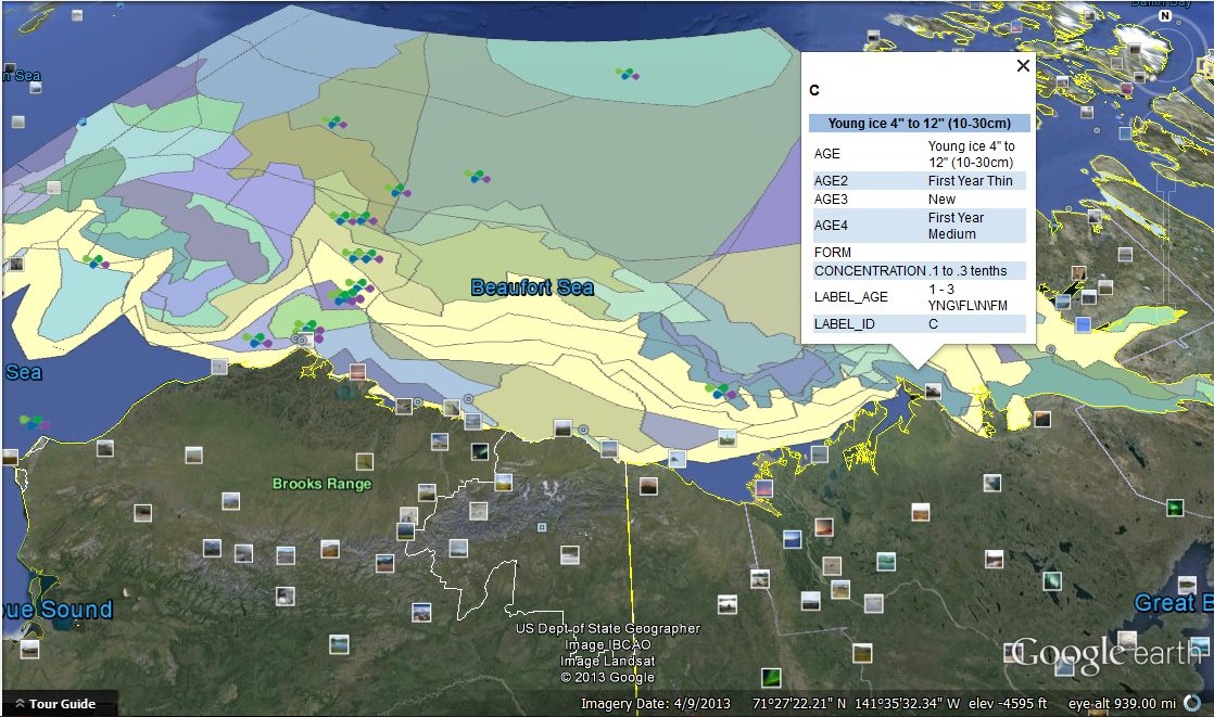
NWS kml ice data file way off when compared to two other Arctic ice chart sources

UPDATE: 20130902
I located the problem in GoogleEarth - Panoramio Photos had an element dated
Full_22Jul13 which displayed sea ice... WTHO? With it removed the NWS kmz ice file is identical to the NWS Sea ICe Analysis chart.


Thanks NWS for helping to resolve this error.  Suggestion - remove Panoramio Photo data elements when working with kmz ice data.

Dramatic difference between the Canadian Ice Service Alaska Coast ice chart and the National Weather Service KML ice file displayed in GoogleEarth. DO NOT RELY ON NWS kmz ICE FILES WITHOUT ANOTHER REFERENCE TO CHECK FOR ACCURACY.

http://pafc.arh.noaa.gov/data/ice/shapefiles/latestIceMap.kmz

Note - no ice pressed up to the Alaska Arctic Coast... next look at NWS kml ice data... OUCH!!!


NW Passage east bound 49 meter motor yacht MICHAELA ROSE at Cambridge Bay contemplates Prince Regent Inlet ice blockage

Who are you going to call?  The Canadian Coast Guard? Yasure! Yabetcha!
At 525 tons the yacht is required to have an ice pilot and is considered a 'commercial' vessel which the Canadian Coast Guard provides icebreaker services to.

References: 
https://www.tc.gc.ca/eng/marinesafety/debs-arctic-acts-regulations-menu-2272.htm
http://www.rccpf.org.uk/passage-planning/arctic

Canada Notices to Shipping and Mariners

Ship Safety Bulletins provide accurate and up-to-date ship safety information vital to the safety of life at sea. They are used to convey information related to safeguarding against identified risks in a timely manner.

Notices to Mariners is a free 24-hour service providing mariners with up-to-date safety advisories. It allows mariners to update navigational charts and understand changes in regulations governing navigation in Canadian waters.

Notices to Shipping are used to inform mariners about hazards to navigation and to communicate other important information.


Check back - will MICHAELA ROSE go north or south from Bellot Strait on their Northwest Passage?

MICHAELA ROSE (GBR)
Harlan Crow, 64, Texas developer and the Crow Family was once the largest landlord in the United States.
Built in 1984, 49m/162ft. steel motor vessel gross tons 525, 2080hp, 3800nm range  @14kts, reported 16 passengers and 13 crew
West to east NWP - reported in Cambridge Bay 20130901


AND WHAT INFORMATION REGARDING PRINCE REGENT INLET BLOCKAGE IS ONLINE?

http://ice-glaces.ec.gc.ca/cgi-bin/getprod.pl?prodid=FICN16CWIS

FICN16 CWIS 011445
Ice forecasts for the Eastern and Northern Arctic issued by
Environment Canada at 11:00 a.m. EDT Sunday 1 September 2013 for
today tonight and Monday.
The next scheduled forecasts will be issued at 11:00 a.m. Monday.

First ice edge estimated from from Borden Peninsula near 7345N 8135W
to 7355N 8155W to Devon Island near 7430N 9000W. Sea ice west and
south of the ice edge.

Second ice edge estimated from Devon Island near 7540N 8030W to 7550N
8010W to Ellesmere Island near 7620N 8425W. Sea ice west of the ice
edge.

Third ice edge estimated from Ellesmere Island near 7730N 7800W to
7730N 7445W then northeastward. Sea ice north of the ice edge.

Queens.
1 tenth of old ice except 7 tenths of old ice from Pullen Strait to
Penny Strait.

Maclean.
Ice covered.

Barrow.
1 tenth of old ice except 6 tenths of first-year ice including 2
tenths of old ice in the southern half.

Jones - eastern half.
Bergy water except 1 tenth of first-year ice including a trace of old
ice in the southwestern section.

Jones - western half.
1 tenth of first-year ice including a trace of old ice except 5
tenths of first-year ice including 1 tenth of old ice in southwestern
section.

Norwegian.
7 tenths of first-year ice including a trace of old ice except 8
tenths of old ice in the western section.

Eureka - southern half.
2 tenths of first-year ice including a trace of old ice except 8
tenths of first-year ice including 1 tenth of old ice within 15 miles
of Stor Island.

Eureka - northern half.
8 tenths of first-year ice including 1 tenth of old ice.

Clarence
West Baffin
East Baffin
West Clyde
East Clyde
West Davis
East Davis
Cumberland
West Brevoort
Central Brevoort
East Brevoort
Frobisher Bay
Northwest Labrador Sea
Navy Board
Pond.
Bergy water.

Kane - southern half.
1 tenth of old ice except 8 tenths of old ice within 10 miles of
Ellesmere Island.

Kane - northern half.
6 tenths of old ice.

Admiralty.
Bergy water except 1 tenth of first-year ice including a trace of old
ice in northern section.

Lancaster - eastern half.
Bergy water except 2 tenths of first-year ice including a trace of
old ice in extreme southwestern section.

Lancaster - western half.
1 tenth of first-year ice including a trace of old ice except 9
tenths of first-year ice including 1 tenth of old ice within 5 to 10
miles of Somerset Island.

Robeson
Liddon
Fitzwilliam
Griper
Ballantyne
Wilkins
Hazen
Gustaf
Peary
Hassel
Massey
South Sverdrup
North Sverdrup
Greely
Nansen
Alert
McClure
Melville
Rae
Byam.
Forecasts available to mariners upon request.

Contact NORDREG Canada via marine radio for routing advice. Arctic
ice analysis charts can be copied on VFA Inuvik at 0200 and 1630 UTC
and on VFF Iqaluit at 0200, 0700, 1100 and 2200 UTC.

End

Continue to check... I'm not very impressed... you really have to dig... 
imagine trying to locate information from sea... I also can see a person 
reading the below information should you call them up on a satcom... if 
this was a aircraft pilot weather briefing it would be totally different... in 
the USA anyway.... lol


http://ice-glaces.ec.gc.ca/cgi-bin/getprod.pl?prodid=FICN14CWIS

FICN14 CWIS 011345
Ice forecasts for the Western and Central Arctic issued by
Environment Canada at 10:00 a.m. EDT Sunday 1 September 2013 for
today tonight and Monday.
The next scheduled forecasts will be issued at 10:00 a.m. Monday.

Ice edge estimated from Beaufort Sea near 7130N 14100W to 7015N
13635W to Tuktoyaktuk Peninsula near 7005N 13055W. Sea ice north of
the ice edge.

Prince Alfred.
5 tenths of first-year ice including 2 tenths of old ice in eastern
section. 9 tenths of first-year ice including 3 tenths of old ice in
western section.

Yukon Coast.
Ice free.

Mackenzie.
Open water except 3 tenths of old ice in the extreme northeastern
section.

Tuktoyaktuk.
Ice free in Kugmallit Bay. Open water in the southern section. 3
tenths of old ice in the northern section.

Baillie.
Open water in Liverpool Bay and in the extreme northeast section. 1
tenth of first-year ice including a trace of old ice except 3 tenths
of old ice in the extreme northwest section.

Banks.
Open water south of Banks Island. 5 tenths of old ice in the southern
section except 9 tenths of old ice in the northwestern section.

Amundsen
Holman.
Open water.

Dolphin
Coronation
Dease
Bathurst.
Ice free.

Maud.
Ice free except open water in Victoria Strait.

Larsen.
Open water except 1 tenth of first-year ice including a trace of old
ice southeast of Gateshead Island.

Peel.
Open water in the southern section except 9 plus tenths of first-year
ice along portions of the Boothia Peninsula. In the northern section,
4 tenths of first-year ice including a trace of old ice except 9
tenths of first-year ice including 1 tenth of old ice over the
extreme northern section.

Regent.
Bergy water in the southern section. 2 tenths of first-year ice
including a trace of old ice in the northeastern section except 7
tenths of first-year ice including a trace of old ice in the extreme
northwestern section.
NOT A CLEAR WARNING.... GO FIGURE!

St. Roch - northern half.
Open water.

St. Roch - southern half.
Ice free.

Boothia.
Bergy water except 8 tenths of first-year ice in extreme southern
section.

Committee.
Bergy water in the extreme northwestern section except 9 plus tenths
of first-year ice including a trace of old ice elsewhere.

North Tuktoyaktuk.
7 tenths of first-year ice including 3 tenths of old ice in the
southern section except 9 plus tenths of old ice in the northern
section.

North Mackenzie.
2 tenths of old ice in the southwestern section. 6 tenths of
first-year ice including 2 tenths of old ice in northeastern section
except 9 tenths of first-year ice including 3 tenths of old ice in
the extreme eastern section.

West Prince Alfred.
9 plus tenths of old ice.

Northwest Beaufort.
5 tenths of first-year ice including 2 tenths of old ice in the
extreme southwestern section. 9 tenths of first-year ice including 4
tenths of old ice elsewhere.

Prince of Wales
McClintock
CT4
South Prince Patrick
CU4
Prince Patrick
Brock
North Prince Patrick
Borden
South Ellef Ringnes
Ellef Ringnes
South Axel Heiberg
Axel Heiberg
Ellesmere
Ward Hunt
Bartlett.
Forecasts available to mariners upon request.

Contact NORDREG Canada via marine radio for routing advice. Arctic
ice analysis charts can be copied on VFA Inuvik at 0200 and 1630 UTC
and on VFF Iqaluit at 0200, 0700, 1100 and 2200 UTC.

End

http://ice-glaces.ec.gc.ca/cgi-bin/getprod.pl?prodid=FICN15CWIS
FICN15 CWIS 011445
Ice forecasts for Hudson and Foxe issued by Environment Canada at
11:00 a.m. EDT Sunday 1 September 2013 for today tonight and Monday.
The next scheduled forecasts will be issued at 11:00 a.m. Monday.

Ice edge estimated from Baffin Island near 6520N 7630W to 6710N 7440W
to 6705N 7650W to 6745N 7845W to 6620N 8105W to Nunavut near 6635N
8235W. Sea ice north of the ice edge.

James Bay
Belcher
Puvirnituq
Coats
Central
Arviat
Churchill
York
South-central Hudson
South Hudson
Rankin
Roes Welcome - southern half.
Ice free.

Resolution
Ungava
Nottingham.
Bergy water.

West Foxe.
Open water.

East Foxe.
Open water except patches of 9 tenths of first-year ice in the
eastern section.

Igloolik - southern half.
Open water except patches of 7 tenths of first-year ice in the
extreme northeastern section.

Igloolik - northern half.
9 tenths of first-year ice including a trace of old ice in the
southern section of Fury and Hecla Strait. Open water elsewhere
except patches of 7 tenths of first-year ice in the eastern section.

Prince Charles.
Open water except patches of 9 tenths of first-year ice in the
eastern and northwestern sections.

Roes Welcome - northern half.
Open water.

Contact NORDREG Canada via marine radio for routing advice. Arctic
ice analysis charts can be copied on VFA Inuvik at 0200 and 1630 UTC
and on VFF Iqaluit at 0200, 0700, 1100 and 2200 UTC.

End

NOT EVEN A MENTION OF FURY & HECLA STRAIT CONDITIONS - WTHO?

Ice Warnings

Ice warnings are part of the ice bulletins and provide notice of possible or increased risks of damage to vessels and equipment, and to the safety of marine navigation and marine activities due to ice.
The following types of ice warnings may be issued:
Rapid closing of coastal leads warning
A rapid closing of coastal leads warning will be issued when significant leads are expected to become blocked by six tenths or more of grey-white ice or older within a 12 hour period. To be considered significant the lead must be:
  • At least 10 nm wide
  • At least 25 nm long
  • Contain no more than three tenths of ice
Ice pressure warning
Strong ice pressure occurs where a ship moves with the ice, and is not able to navigate. The ship may be pushed on the side or lifted. At the same time, ice ridges may be actively building.
Special ice warning
A special ice warning will be issued for the following situations:
  • When one tenth or more of greywhite ice or older is expected to be in an area when ice is not normally present.
  • Any unusual or significant ice event that is or could present a hazard to navigation.
http://www.ccg-gcc.gc.ca/eng/CCG/Ice_Home

Icebreaking Services

The Arctic and Hudson Bay are accessible for only six months of the year, leaving a very short navigation season for the resupply of Northern settlements and military sites.
The Canadian Coast Guard (CCG) provides Icebreaking services to ensure that marine traffic moves safely through or around ice covered waters. Icebreaking supports economic activities by assisting commercial vessels to voyage efficiently and safely through or around ice covered waters. With icebreaking services, most Canadian ports are open for business year-round.

Icebreaking Levels of Service

http://www.ccg-gcc.gc.ca/folios/00028/docs/IcebreakingLOSENFR-eng.pdf

Ice Operations Centers

Great Lakes and Arctic

Open 365 days a year  7 days a week / 24 hours a day  Information on icebreaking operations  Telephone: 1-800-265-0237  Information on ice conditions  Telephone: 519-383-1855  Fax: 519-337-2498

NOTE: NO E-MAIL CONTACT WHICH THE ATLANTIC OPS CENTER LISTS... lol

Map of Northern Canada Vessel Traffic Services Zone
Address: NORDREG CANADAMCTS Centre: Iqaluit, Nunavut
Call Sign: VFF
Operational: Approximately mid-June to late November:
Email: IQANORDREG@INNAV.GC.CA

Telex (telefax): 063-15529
Telegraphic address: NORDREG CDA
Telephone: (867) 979-5724
Fax: (867) 979-4236

Icebreaker program information on request at stacy.dufour@dfo-mpo.gc.ca
Do you get the same feeling as I am that Government is making a gigantic deal out of icebreaking services?

Comments:

Manager, Icebreaking Program Canadian Coast Guard200 Kent St., 5th Floor
Ottawa, Ontario KIA OE6

Fax: 613-998-8428For questions, comments or suggestions, contact us by email at
ice-glace@dfo-mpo.gc.ca


Carry on...

Prince Regent Inlet blocked on September 1st to yacht traffic on a Northwest Passage - ICEBREAKER?

Today is September 1st, Prince Regent Inlet is blocked with a solid band of 7/10 concentration sea ice.


I believe icebreaker assistance would be required for a yacht to transit this blockage. The CCGS HENRY LARSEN is at Pond Inlet.


Sailing Cat LIBELLULE's blog continues with wonderful NW Passage content to share


Pearce Point Harbour

PC
01/09/2013, Pearce Point Harbour Amundsen Gulf


Decided to stop in a beautiful bay named Pearce Point Harbour, 420 nm west of Cambridge Bay. We will stay for 1-2 days to wait for a depression to pass through (W Announced gusts up to 40 kts) before procédure around Cape Bathurst. 


Clearly We can feel the effects of Being further south again: The nights are getting longer, we HAD 6 hours of darkness last night. And it is very warm (air temperature 8-10 C, water temperature 4-6 C).


Anchor drag

PC
01/09/2013, Pearce Point Harbour
The last 24 hours Were not our Favoured: 
- We Almost lost our first dinghy in the open seas When one of the rolls of the davit broke and started dragging the dinghy behind the boat, with 2 m waves crashing over it
- then here in oz the bay and our anchor dragged the alarm Did not go off, so we only Realized Effective A couple of hundred meters ...
- then we reanchored about 5 times and the anchor is still dragging, the ground in this bay Seems to be gravel, in nor we nor any box Traversay are holding, so we continue to re-anchor, be dragged for 200 meters, re-anchor, be dragged for 200 meters with engine running, etc. etc.. And all this in heavy winds of 35 kn, with max gusts 45 kn
-. now and it even started snowing horizontally
fortunately, the wind should start decreasing to 25 kn in the next couples of hours, lets hope ...


So how does the ice at Cape Bathurst look? Much better than days ago...


and the weather forecast?

Baillie: Forecast

Tonight and SundayGale warning in effect.Wind west 20 knots increasing to southwest 35 late overnight then diminishing to northwest 30 Sunday morning. Wind diminishing to northwest 20 Sunday evening.Tonight and SundaySeas 2 metres building to 3 early Sunday morning then subsiding to 2 Sunday evening.

Extended Forecast

Issued 07:00 PM MDT 31 August 2013
MondayWind northwest 20 knots diminishing to light late in the day.
TuesdayWind light increasing to east 25 knots late in the day.
WednesdayWind east 25 knots diminishing to southwest 20.

Recommendation: This is nothing compared to what you face in the Bering Sea so every day you delay now means one less day of margin in the Pacific. I'm not one to push into 999mb weather but... with warm weather icing is not a problem.


The bigger weather picture: (OUCH! a 976mb low in the Bering Sea... do you get the picture of what can be ahead?)

FZAK62 PAFC 011153
OFFALU

OFFSHORE WATERS FORECAST
NATIONAL WEATHER SERVICE ANCHORAGE AK
400 AM AKDT SUN SEP 1 2013

OFFSHORE WATERS FORECAST FOR THE BERING SEA

WIND FORECASTS REFLECT THE PREDOMINANT SPEED AND DIRECTION
EXPECTED. SEA FORECASTS REPRESENT AN AVERAGE OF THE HIGHEST
ONE-THIRD OF THE COMBINED WIND WAVE AND SWELL HEIGHT.

PKZ499-020300-
400 AM AKDT SUN SEP 1 2013

SYNOPSIS FOR CENTRAL BERING SEA

A 975 MB LOW NEAR 54N 174E WILL MOVE TO NEAR 53N 175W AT 978 MB EARLY
MON MORNING AND THEN MOVE TO NEAR 56N 167W AT 980 MB TUE MORNING. A
983 MB LOW WILL FORM NEAR 58N 172W THIS EVENING AND MOVE TO NEAR 60N
172W AT 982 MB EARLY TUE MORNING.

PKZ411-020300-
BERING SEA OFFSHORE WEST OF 180 AND EAST OF THE INTERNATIONAL
DATELINE
400 AM AKDT SUN SEP 1 2013

STORM WARNING MONDAY

TODAY
N OF 56N...NE WIND 25 TO 35 KT. S OF 56N...SE WIND 25 KT
BECOMING NE 30 KT IN THE AFTERNOON. SEAS 10 TO 14 FT. RAIN SHOWERS

TONIGHT
N WIND 35 TO 45 KT. SEAS 15 TO 20 FT. RAIN.

MON
N WIND 40 TO 50 KT. SEAS 20 TO 25 FT. RAIN.

MON NIGHT
NW WIND 40 KT. SEAS 21 FT.

TUE
NW WIND 30 KT. SEAS 14 FT.

WED
NW WIND 20 KT. SEAS 10 FT.

THU
NW WIND 15 KT. SEAS 7 FT.


PKZ412-020300-
BERING SEA OFFSHORE 171W TO 180 AND NORTH OF 56N
400 AM AKDT SUN SEP 1 2013

GALE WARNING TONIGHT AND MONDAY

TODAY
SE WIND 30 KT. S OF 58N...VARIABLE WIND 15 KT. SEAS 9 FT.
PATCHY FOG. RAIN.

TONIGHT
N WIND 30 TO 45 KT. E OF 175W...VARIABLE WIND 20 KT. SEAS
9 FT BUILDING TO 14 FT AFTER MIDNIGHT. PATCHY FOG. RAIN.

MON
N WIND 40 KT. SEAS 18 FT. RAIN.

MON NIGHT
N WIND 35 KT. SEAS 17 FT.

TUE
NW WIND 35 KT. SEAS 15 FT.

WED
NW WIND 25 KT. SEAS 12 FT.

THU
NW WIND 20 KT. SEAS 8 FT.


PKZ413-020300-
BERING SEA OFFSHORE 171W TO 180 AND SOUTH OF 56N
400 AM AKDT SUN SEP 1 2013

GALE WARNING MONDAY


TODAY
S WIND 20 KT. SEAS 8 FT. PATCHY FOG. RAIN.

TONIGHT
VARIABLE WIND 20 KT. SEAS 8 FT. PATCHY FOG. RAIN.

MON
NW WIND 35 KT...EXCEPT VARIABLE 15 KT E OF 175W. SEAS 11 FT
BUILDING TO 17 FT IN THE AFTERNOON. RAIN.

MON NIGHT
NW WIND 40 KT. SEAS 18 FT.

TUE
NW WIND 35 KT. SEAS 16 FT.

WED AND THU
NW WIND 20 KT. SEAS 10 FT.


PKZ414-020300-
BERING SEA OFFSHORE EAST OF 171W
400 AM AKDT SUN SEP 1 2013

GALE WARNING THROUGH TONIGHT

TODAY
S WIND 25 TO 35 KT. SEAS 6 TO 10 FT. AREAS OF FOG. RAIN.

TONIGHT
S WIND 25 TO 35 KT. SEAS 10 FT. AREAS OF FOG. RAIN.

MON
S WIND 25 KT. SEAS 8 FT. PATCHY FOG. RAIN.

MON NIGHT
S WIND 25 KT. SEAS 8 FT.

TUE
W WIND 25 KT. SEAS 11 FT.

WED
SW WIND 25 KT. SEAS 10 FT.

THU
SW WIND 20 KT. SEAS 7 FT.