Tuesday, August 27, 2013

S/V TRAVERSAY III updates the run of five yachts to Cambridge Bay - Time is of the essence!


SV Traversay III


Tuesday, 27 August 2013

Onward ...

As the gale that had us pinned down in Willis Bay, Prince of Wales Island, began to reduce its intensity, the August 25 ice charts showed that those strong west winds had had a profound effect in reducing the ice in Peel Sound.

The idea was briefly mooted of leaving the next morning when the winds and waves would have further reduced. After some discussion, this course of action was rejected by all the boats in favor of an immediate departure. A delay would have risked a tongue of ice extending from M'Clintock blocking our path AND a number of boats were beginning to worry about fuel shortage. A fair sailing wind, no matter how strong, would grant many free miles and reduce this concern.

Victoria Strait on the west side of King William Island is described in the government "Sailing Directions" as having the worst ice conditions in mainland Canada. This route spelled the end of the Franklin Expedition in 1845. Amundsen succeeded in the first Northwest Passage by proceeding south along the east shore of King William. The route to the east of King William via Gjoa Haven is, even today, typically more reliable but adds two or three days to a very time-constrained voyage.

It was our good fortune that the gale which cleared Peel Sound of ice also demolished most of the ice blocking Victoria Strait. All five boats that were anchored in Willis Bay [TRAVERSAY III, ACALEPHE, BELLE EPOQUE, ISATIS and LIBELLULE] are now approaching Cambridge Bay after a three day passage.

It is our plan to refuel as quickly as possible and be underway toward the west in less than a day. It is a sobering thought that in five or six weeks it will be possible to WALK across Cambridge Bay. Time is of the essence!

Claude is leaving us in Cambridge Bay and we want to thank him for helping us thus far on our trip … we never could have done it without him. He will be greatly missed and not only for his dishwashing and cooking skills. While with us, he engineered a successful "fix" of our anchor windlass, he made helpful suggestions about how we could save energy in the galley and save heat from escaping from our companion-way hatch. He also helped us with some great sailing tips. He left earlier than expected due to pressing obligations at home in Quebec. I'm sure Normande will be thrilled to have him back - just one day late for his birthday!

Our next problem shaping up is that Cape Bathurst - four days travel to the west - is blocked by 20 miles of five-tenths ice. As we saw in Peel Sound, a gale can change the situation radically but you have to be nearby to take advantage. Thus we, and probably the other boats too, will be on our way toward this obstacle in the hope that it will allow our passage.

Beyond, there is open water along the Alaska Coast ... for a while anyway.

-----

At 27/08/2013 23:04 (utc) our position was 68°49.01'N 104°33.76'W

http://traversayiii.blogspot.com/


Arctic Alaska Sea Ice Risk Scenario - A high alert needs to be kept for early warning

Uwe in Germany is concerned, as I am, about the Beaufort Sea ice moving south into the Arctic Alaska coastline and creating a gigantic sea ice blockage for marine traffic.

Take a look at the current satellite images, natural and with false colors, then compare your observations with the current National Weather System ice chart for Arctic Alaska.

http://ice-glaces.ec.gc.ca/prods/MODISCOM-T/20130826000000_MODISCOM-T_0007233842.jpg

http://ice-glaces.ec.gc.ca/prods/MODISCOM-F/20130826000000_MODISCOM-F_0007233841.jpg


http://arctic.arh.noaa.gov/ice_anal.php


Next, do you remember the Arctic Cyclone of 2012This cyclone’s central sea level pressure reached about 964 millibars on August 6, 2012—a number more typical of a winter cyclone. That pressure puts it within the lowest 3 percent of all minimum daily sea level pressures recorded north of 70 degrees latitude. This storm formed and intensified near the Beaufort Sea and moved to the central Arctic Ocean where it slowly lost its intensity over the next several days. Ordinarily, the Beaufort Sea and the Arctic Ocean are dominated by high pressure, so having a low pressure system form and intensify here is quite uncommon.


I don't need to remind you what the consequences could be if there was a major low pressure weather system in Arctic Alaska during the time when Northwest Passage yachts are making a westward run from the Mackenzie River area of Canada. Here is today's NWS weather forecast across the western Arctic region. 998 millibars is not low enough to worry me today... but the Fall to winter tropical weather systems from the Orient will soon be marching our way into Alaska with Siberian weather spiraling eastward colliding in Arctic Alaska. OUCH! Super storm? Cyclone?

My advise for NWP yachts - stage at Tuktoyaktuk or Herschel Island and identify a minimum 3-4 day good weather window to 'turn the corner' at Point Barrow for Nome Alaska.
STAY TUNED IN - this is not over until the fat lady sings in October.

Leaving your sailboat in Nome on the hard for the Alaskan winter? I do not recommend it!

I do not recommend putting your boat 'on the hard' in Nome Alaska for the winter. If you need to ask why then you really do not understand the risks, preparations and likely condition of your boat when you return. What does your insurance say about storage on the hard in Alaska? Freezing damage covered? The Arctic winter is extremely hash on equipment. Be sure to compare prices and if the business has all-risks insurance... lol Will your boat be secure?  Not likely... OMG!

Can your boat be pulled safely out of the water using a trailer onto the hard? Only you can make that decision because you will undoubtedly have to sign a full release of all risk and/or damage waiver. You have been warned! 

Sail on to Sand Point Alaska to a milder climate with a marine Travelift to move your boat. Kodiak, Homer, and Seward are alternative choices. The best? Motor south through the Inside Passage protected waters to British Columbia, Washington or Oregon State. 

On a budget with time to sail/motor south - consider the Port of Astoria Oregon at the sea entrance to the Columbia River up to Portland Oregon. 

http://www.portofastoria.com/
http://www.portofastoria.com/boatyard_rates.html
http://www.portofastoria.com/marina_west_boaterInfo.html
http://www.portofastoria.com/marina_east_boaterInfo.html
http://www.portofastoria.com/tonguepoint_geninfo.html
http://www.portofastoria.com/tonguepoint_moorage.html


Foreign vessel?  Make sure you secure a valid Cruising Permit when entering the USA (Canada) - https://help.cbp.gov/app/answers/list/kw/OBTAIN%20CRUISING%20PERMIT )

BALTHAZAR on the hard in Nome for the 2013-2014 winter.


Do you think it will be sitting like this come Spring? NOT!!!


Kodiak Shipyard - 600T Travelift


Port of Astoria haulout boatyard


Or the North Tongue Port at Astoria Oregon

North Tongue Point Marine Facility

Port of Astoria West Marina

Western Arctic navigation choke-point enlarging - time for CCG icebreaker to help and prevent delays

While 2/10 ice doesn't look like much of a problem - it is for a small yacht. It is time for the Canadian Coast Guard to be proactive and provide an icebreaker to assist vessels transiting this area. Waiting longer will jeopardize the safety of vessels delayed in making a long passage to the Bering Strait and beyond.

It is the responsibility of the Canadian Coast Guard (CCG) Icebreaking Program to ensure that marine shipping moves in a safe, timely and efficient manner through or around ice-covered waters.

Canadian Coast Guard Arctic Region:

Email: info@dfo-mpo.gc.ca

Telephone: 613-993-0999
Fax: 613-990-1866
Toll free (within Canada) 1-800-267-7270
Phone 1-613-965-3870


Update and suggestion for CCG icebreaker escorts

Douglas PohlTue, Aug 27, 2013 at 7:27 AM
To: Canada Coast Guard <info@dfo-mpo.gc.ca>

As you may well be aware a situation is occurring at Cape Bathurst with Beaufort sea ice pushing south and creating a blockage for marine vessel traffic.

I suggest you evaluate early action to use a CCG icebreaker to keep this choke-point open. Within the near future up to seven yachts will be westbound from Cambridge Bay to escape the Arctic winter freeze-up.

The Canadian Coast Guard would be well served to have an icebreaker near Cape Bathurst conducting vessel escorts through this choke-point.  

What a great opportunity for public relations!

Thank you for your attention to this urgent matter.

Regards,

Douglas Pohl


Monday, August 26, 2013

VIDEO - You don't want your boat rescued by an icebreaker - will you and your boat both survive the rescue?

I thought I'd share this video of the S/V FINE TOLERANCE being towed out of pack ice by a Canadian Coast Guard icebreaker.

YOU REALLY DO NOT WANT TO EXPERIENCE THIS WITH YOUR VESSEL - PLEASE GET OUT OF THE ARCTIC ASAP!

Video url: http://youtu.be/nsOsWEo4p1Y

MainstreamLastFirst "Pulling Together" ends their 2013 expedition half-way in Cambridge Bay


REAL LIFE IS ON THE HORIZON…

The novelty has now officially worn off being wet and cold…. The misery I/ spoke about before is now just miserable! The good news is that we are within reach of the end point where a warm shower and a bed are on the cards. Its a funny thing, I am trying so hard not to wish away the last few days. I know my bed will be there waiting for me in four days or fourteen but I may never be back in this harsh but wonderful place. Trying to stay in the moment is very difficult. We sent the best part of 2 years putting this expedition together and I spent every waking moment looking forward to it.. What the hell was I thinking! I suppose when I have time to reflect on the trip once its all done and dusted I will forget the rough times.
When I’m on the oars I’m constantly thinking about the pleasures of home, these guys are awesome and I have made friends for life (I’m not sure what the lads would say about that!!) but 70 days in total in the constant company of three hairy, and now very smelly men is just starting to get old. Myself and Paul were trying to work out how long it would take for friends to clock up the hours that we have all clocked up in each others company. There is not much about these guys I don’t know now. If I was to try and sum them up, Kevin is an academic trapped in an adventurers body, Frank would have been right at home driving a dog team in the late 1800′s, Paul is a record keeper constantly taking notes in his little diary, and I’m not sure what I am apart form bloody freezing, hungry and exhausted!
The funny thing is that every time we think we are making progress and start planning forward something happens to stop us in our tracks, like literally as I type this I hear the lads talking about the fresh water supply… its basically become contaminated with sea water.. So now the priority has changed from charging on to Cambridge Bay to looking for a creek on the shore to fill some water tanks from, talk about a curve ball… right thats me off to find some water I suppose…… did I mention I’m cold?
PS. Im loving every minute still, bed can wait..
~Denis

BEGINNING WITH THE END IN MIND

One of the habits the late Stephen Covey speaks about in his best selling book 7 habits of highly effective people is “beginning with the end in mind”. This simple but in my opinion highly effective idea is something I use in my own life and often discuss with clients.
After 2 days of stormy winds, we got going again today and I think we were all definitely beginning this morning with the end in mind. This has been an incredible experience so far but I know I am ready to get this done now and get to Cambridge Bay. We were chatting about this earlier today and we’re all on the same page.
Depending on the weather, we’re anything from 2 to 5 days out. At this stage, we should know better not to try and plan how long anything up here will take but with the end so close it’s hard not to. The temperature has dropped off a bit over the last few days so a real bed, a hot shower and a warm meal sound very appealing right about now….
~Paul

HUNKERING DOWN WHILE THE STORM PASSES

tent ready for storm small
The walls of the tent are shaking and shuddering violently. Several strong gusts push the tent fabric right down upon us, the tent poles giving way to the extreme force. The guy wires are as taught as cables and prevent the poles from breaking, large stones hold down the perimeter of the fly and help keep us stuck to the ground. Can our tent survive this pounding? Clearly our storm has built way beyond a gale.
We sail into our current camp on a strong southwesterly that literally pushes us faster than we can row. By cranking the rudder away from land and then letting the on-shore wind do its thing we move along at a comfortable 5kmph running exactly in the direction we want to go. Rowing the Arctic Joule requires pointing the bow more towards shore – the forward propulsion pushing her away from land – and produces an inconsistent movement that before long has us correcting course, heading in and out. The back and forth proves slower than doing absolutely nothing at all. It’s bizarre and it’s magic, the arctic giving us a freebee for the moment.
Our joy ride lasts about an hour until the wind swiftly changes direction and hints at the big nasty that awaits us. It’s our cue to hit shore.
The beach is moderately steep and we haul The Arctic Joule as high up on it as we can. There are no large boulders to anchor our pulley so we fill our large packs with gravel and use them as dead weight to haul by. It’s a gap stop solution but its all we can do. The Arctic Joule weighs over 2000lbs and doesn’t manhandle easily.
Arctic Joule in surf small
Our storm builds and so does the surf. The Arctic Joule begins to get pounded. We’re genuinely concerned that the boat could work itself loose and be blown out to sea. The wind blows off-shore and an unanchored Joule would be carried away as swiftly as a feather in the wind. We put ourselves on a round-the-clock monitoring vigil until the wind dies down.
Joule from far small
I write this blog from the vestibule of our 6-person tent. It’s the middle of the night (my less-than-ideal shift of 4am-6am is the result of a loosing score in our evening game of hearts) and the wind is howling all around me. Every few minutes I visually check on the boat, every hour I check on the guy lines of the tent. The updated forecast is for sustained 55KN winds (100kmph) with gusts potentially 40% greater.
I have a steaming cup of soup in my lap, my journal in my hand and my shotgun at my side. It all feels strangely familiar to me now.
~Kevin

(Oops... if they cannot draw correct after a month of rowing how could they actually do it? BACKWARDS says it all.)


STORM TENSION

weather report small
It’s 2am as I settle into the small vestibule – it’s a snug little front area separate to the main part of the tent which offers a view of the beached boat about 100 yards away, through the small air vents. Surrounded by our cooking equipment, dry suits, shot gun and a few other essentials I make myself a hot coffee. Between the coffee, the vestibule and my 5 layers of clothing, it’s not too cold. The 3 lads are in their sleeping bags; I decide to throw on a pot of noodles to accompany the coffee. Frank did the first watch from midnight to 2am so now it’s my turn.
We’re on land and have beached the boat. Originally we received a gale warning which was subsequently upgraded to storm force. We’re in the middle of 55 knot winds (about 100km an hour) and gusting higher. We’ve used 3 separate anchor points to secure the boat as best we can. We agree to maintain a watch throughout the night as there is a huge amount of tension on the anchor lines. The tent is also under enormous pressure from the power of the ferocious wind.
As the Arctic Joule is being slapped about by the thrashing waves, it rocks the anchor points. We’ve used hundreds of pounds of rocks and loose stones (packed into bags) to add more stability but there is still the risk (hopefully a small one) that the lines could snap and the boat gets swept out to sea such is the pressure Mother Nature is exerting on her. So maintaining a watch all night is a must.
wind building small
The order of the watch is decided over a game of hearts. Frank won and opts for the first shift, I was second and so follow him with Kevin next and Denis taking the last shift from 6am to 8am.
Personally I believe a certain amount of tension or stress is healthy. I think it enables growth and performance in so many ways. Like exercising for example, pushing the body and putting it under stress when we train. Combine this with adequate rest periods for recovery and the body becomes stronger, fitter and healthier.
We certainly have plenty of tension in our little world tonight as we watch over the boat while also hoping that the tent poles don’t snap in the stormy winds – no doubt this is serious stuff.
Every 5 to 10 minutes, I peer out the vent to make sure the boat is still there. I then go back to my chosen activity to pass the time which tonight is writing. I’m actually really enjoying this time jotting down notes, thoughts, ideas and whatever else comes to mind. At 3am, I go down to the boat to check the lines. I bring the shot gun with me in case I stumble upon a grizzly – highly unlikely but no harm in being safe.
The temperature is below freezing tonight, it’s dark, we’re in the middle of an Arctic Storm, I’m carrying a loaded shot gun for protection and the boat is under serious pressure from Mother Nature. All in all we’re in a very exposed position but yet I find myself actually enjoying this. Am I a bit odd, maybe a touch adventurous or perhaps its just easy to enjoy a situation like this when you feel you have things under control (or at least as much control as is possible in this situation).
At 4am I go out again to check the lines before Kevin takes over – all good and secure. I join the lads in the tent and climb into my sleeping bag and quickly nod off to the sound of the howling wind and the flapping of the tent. Another interesting day in the Arctic…….
~Paul


My Arctic Forecast : Doubling Of Arctic Ice In 2013

http://stevengoddard.wordpress.com/2013/08/26/my-arctic-forecast-doubling-of-arctic-ice-in-2013/


My Arctic Forecast : Doubling Of Arctic Ice In 2013

Arctic ice melt has dropped to almost zero. Comparing current ice vs. mid-September 2012, there is more than 100% more ice than at last year’s minimum. A rapid freeze between now and mid-September could make this number much larger.
The map below compares current ice (green and yellow) vs. mid-September 2012 (red and yellow)
ScreenHunter_419 Aug. 26 10.15
In their ongoing efforts at plausibly deniable polar ice propaganda, NSIDC describes this spectacular doubling as “won’t match last year’s melt
Leading experts say that all of the ice is going to melt in the next few hours.
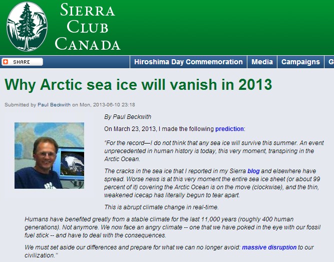
the Arctic will be ice-free in the summer of 2013
- John Kerry, US Secretary of State
ScreenHunter_409 Jan. 18 21.32
James Hansen : ‘This is the last chance’
6/23/2008
“We see a tipping point occurring right before our eyes,” Hansen told the AP before the luncheon. “The Arctic is the first tipping point and it’s occurring exactly the way we said it would.”
Hansen, echoing work by other scientists, said that in five to 10 years, the Arctic will be free of sea ice in the summer.
June 26, 2013
The alarming loss of sea ice which has grown worse each summer over the past several decades, has taken a sharp turn for the worse: this year the loss is right in the middle, the most resilient part of the ice cover. This could lead to a completely ice-free Arctic Ocean by September.
ScreenHunter_165 Jul. 17 11.51

Mind reading impossible but escaping from the Arctic winter means using every opportunity to make progress

WHEN another vessel approaches your location you can see them approaching from maybe up to 25 nm distant. It all depends on your AIS/VHF radio antenna location - the higher, i.e. on a sailboat mast, the greater the effective signal distance.

So why wouldn't you maintain a marine "watch" system? To ensure safety from such common calamities as dragging anchor, a storm front passage, a polar bear attempting to climb aboard, drifting ice trapping your vessel and A PASSING ICE CLASS SHIP SUCH AS MV HANSEATIC OR CCGS icebreaker HENRY LARSEN.

The MV HANSEATIC crossed through Bellot Strait southbound on 20130825 for Gjoa Haven.

Not one of the yachts made an attempt to communicate or request permission to follow her at slow-bell to Gjoa Haven. Hummm? Must be happy to winter over in the Arctic... there is some 37 days at 5kts to travel before reaching a safe winter port such as Sand Point Alaska... time is of the essence! Maybe I shouldn't worry... but with many years of sea service in the Bering Sea I can guarantee you there is going to be a Fall storm of epic proportions and someone is going to pay a very dear price - yachts must get out of the Arctic ASAP.


More of the Swiss sailing catamaran LIBELLULE story - a family with three children taking a summer vacation cruise through the Arctic Northwest Passage... http://www.sailblogs.com/member/libellule/?xjMsgID=285060


Ice Maze, second episode

MD
24/08/2013, South Peel Sound


According to a map of ice NOAA 5 am, a breakthrough show west of Peel Sound.
We decided to try our luck. Other boats (Traversey III Acalèphe and two other newly arrived boats - Isiatis and Belle Epoque). Decided to await the arrival of the next ice chart Canadian 12H
Unfortunately, the inventor of the ice maze forgot inserted in his notebook the last page with the solutions - the output does not exist! - That the dense ice in the southern South Peel, without passage for us. "But this time, says Anissa (8 years), this is not a game, but a labyrinth for real!"
So here we are now on the way back to Willis Bay where we take shelter during 48 hours until the strong wind NW announced has passed.
Snowing ...

NW Passage 


Polar bear

Anissa
24/08/2013


Gestern haben wir einen Eisbaeren gesehen. Er war auf einer Eisscholle und neugierig schaute each year.


NW Passage
Der Moschusochse

Line
24/08/2013 Peel Sound


The musk ox is a great way cow or yak. He is the resident arctic tundra that is Greenland, Canada and Alaska. Forty years ago, however, a herd of muskoxen in northern Siberia was seen and now live in Norway and Sweden smaller herds.
Previously, the ancestors of the extinct musk oxen were moschatus, warmer climates usual year. Only by adapting year colder places the musk ox survived. Most of muskoxen can only be up to 20 years old. But for many of them die before starving year if they have not grown enough fat reserves for the winter last year, or year or freezing drowning when they break through the ice of frozen rivers. At the moment there are in the world throughout the whole about 30,000 musk oxen, which really is not much, I think.
The natural enemies of wolves and polar bears are the musk ox.
Muskoxen prefer as habitat locations where there is little rain. Although they live in the cold, but they are sensitive to sustained moisture. Mostly they keep to the banks of rivers or in valleys and low-lying levels. Eat of birch trees or woody plants such as willows, from which they strip the leaves, and how of various herbs mosses. For protection against the cold, the muskoxen have a kind of fat and then the thick, dark brown fur that about eight times as warm as wool and as soft as cashmere. On average they weigh 300 kg and are 2.4 m long and 1.4 m high. And they have a thick mane and distinctive curved horns.
During the summer the herds are large 5a 15 musk oxen in winter they can grow up to 100 animals. In the herd, almost everything is in sync with the musk ox: The feeding and rest periods that last around two hours, all of the herd followed. Per day they lay back an average of 2 km, which is not much they move slowly aussi. The group has almost always a leader, usually an older animal. A few days ago we have seen from the boat eight on the country yesterday musk ox and six close when walking.


ARCTIC EXIT URGENCY?  YOU DECIDE BY FOLLOWING ALONG... I'M VERY WORRIED ABOUT THEIR SAFETY !!!


Canadian marine weather compared with USA NWS Marine Weather - Unified KML files would be fantastic

Follow me for a minute while I attempt to check marine weather for a specific graphical location (you shouldn't need to know a foreign country's naming convention to locate regional marine weather). I know the location is between Cambridge Bay and Bellot Strait and is called Queen Maud by Canada Ice Service but I also recognize this region by the geographic islands and should be able to click on a graphic map.

Google Canada marine weather and first hit is
 http://weather.gc.ca/marine/index_e.html

which displays a graphic map - wow - the Arctic is under a big RED warning.


So I carefully click on the location I think is Queen Maud. What appears is:
Another graphic with more detailed areas - why not revise this graphic into east-west zones instead of the previous larger scale - you will note the error from the previous map saying there is a very large scale RED warning when the below map shows just a single RED warning area. Hummm.... maybe this is a scare tactic to keep boaters in port? :-)

http://weather.gc.ca/marine/region_e.html?mapID=05


OK so a new graphic requires ANOTHER click to advance to usable information so I click on the graphic area I'm interested in and notice the name is actually LARSEN and what appears?


Usable weather information - kind of...


If I want current weather condition I click the tab labeled "Weather Conditions" and this appears:

http://weather.gc.ca/marine/weatherConditions_e.html?mapID=05&siteID=08900&stationID=


Not really "Weather Conditions" for LARSEN but ANOTHER DAMN GRAPHIC TO CLICK.

I think this Canadian Weather system was designed by a WEBMASTER who enjoys clicking... undoubtedly Windoz trained.

Clicking on a nearby weather station named GATESHEAD ISLAND produces yet another graphic:
http://weather.gc.ca/marine/weatherConditions-currentConditions_e.html?mapID=05&siteID=08900&stationID=NGH

Wrongly named LARSEN when it is GATESHEAD ISLAND.

I now have the marine forecast and current weather conditions for a Canadian location. Lets try the USA National Weather System for a marine forecast.

Google "USA marine weather" and this link appears http://www.weather.gov/ which opens a graphic:


Lets check what is going on at the top of Alaska, aka Point Barrow so I click the Alaska map which open a graphic at http://pafg.arh.noaa.gov/


Once more click on Barrow produces http://forecast.weather.gov/MapClick.php?zoneid=PKZ235 with graphics:


There are links to tide information, text only forecast and printable forecast.
And just for the record there was a very nice link on the previous page: 

http://pafg.arh.noaa.gov/wmofcst.php?wmo=FZAK69PAFG&type=marine

With all of the Offshore Forecast for the US Arctic Waters.


While NOT perfect it is missing a link for SEA ICE. A bit of searching does produce a link: http://pafc.arh.noaa.gov/ice.php which should be on the original webpage - HEADS UP NOAA NWS ARCTIC WEBMASTER.

WHAT I WOULD REALLY LIKE TO SEE:

1) A large graphic with individual zones that reduces the need to click over and over to "drill-down" - see: http://www.weather.gov/ add a full size Alaska zone map below the USA 48 on the same webpage. Saves two clicks.

2) A unified sidebar menu - different USA zones with different menus are confusing - shouldn't the sidebar menus be listed alphabetically?

3) A query or search bar for drilling down within the NWS website - not the web.

4) PLEASE ADD an advance user interface - lat/long period query producing a KML downloadable animated weather meta data file. Much like GRIB files except for use with Google Earth. There are KML files for sea ice - why not for all weather? 

BOTTOM LINE - KUDOS TO THE NWS - GREAT USER FRIENDLY PRESENTATION - PLEASE KEEP MAKING IMPROVEMENTS FOR MARINERS AT SEA TO FIND AND DOWNLOAD OVER SATCOM THE DATA THEY NEED FOR SAFETY AT SEA.